Area photos
Choose a location
Abbey Road
Abbey Wood
Abridge
Acton
Acton Central
Acton Town
Addington
Addiscombe
Addlestone
Albany Park
Aldgate
Aldgate East
Aldwych
All Saints
Alperton
Amersham
Angel
Archway
Arena
Arkley
Arnos Grove
Arsenal
Aveley
Baker Street
Balham
Bank
Barbican
Barking
Barking Riverside
Barkingside
Barnehurst
Barnes
Barnes Bridge
Barnes Cray
Barnsbury
Barons Court
Batchworth
Battersea
Battersea Park
Battersea Power Station
Bayswater
Becontree
Beddington
Belgravia
Belhus,
Bellingham
Belmont (Middlesex)
Belsize Park
Belvedere
Bermondsey
Berrylands
Bethnal Green
Bexley
Bexleyheath
Bickley
Birkbeck
Blackfriars
Blackheath
Blackhorse Lane
Blackhorse Road
Bloomsbury
Bond Street
Borehamwood
Borough
Boston Manor
Bounds Green
Bow
Bow Church
Bow Road
Bowes Park
Brent Cross
Brent Cross West
Brentford
Bricket Wood
Brixton
Brockley
Brockley Hill
Bromley Common
Bromley North
Bromley South
Bromley-by-Bow
Brompton
Brondesbury
Brondesbury Park
Brooklands
Bruce Grove
Buckhurst Hill
Burgess Park
Burnt Oak
Bushey
Bushey Heath
Byfleet and New Haw
Caledonian Road
Camberwell
Cambridge Heath
Camden Road
Camden Town
Canada Water
Canary Wharf
Canning Town
Cannon Street
Canons Park
Carpenders Park
Catford
Catford Bridge
Chadwell Heath
Chalfont & Latimer
Chalk Farm
Chancery Lane
Chandler’s Cross
Charing Cross
Charlton
Chelsea
Chenies
Chertsey
Chesham
Chevening
Child’s Hill
Chipping Barnet
Chiswick
Chorleywood
City of London
City Thameslink
Clapham Common
Clapham High Street
Clapham Junction
Clapham North
Clapham South
Claremont
Clerkenwell
Clock House
Cockfosters
Colindale
Coombe (Croydon)
Coombe (Kingston)
Corbets Tey
Cottenham Park
Coulsdon
Covent Garden
Cowley
Cranham
Crayford
Crayford Ness
Creekmouth
Cricklewood
Crossharbour
Crouch End
Crouch Hill
Croxley
Croydon
Crystal Palace
Cubitt Town
Cudham
Cutty Sark
Dagenham East
Dagenham Heathway
Dalston
Dalston Junction
Dalston Kingsland
Dancers Hill
Dartford
Debden
Denham
Denmark Hill
Deptford
Devons Road
Dollis Hill
Dormers Wells
Downham
Drayton Green
Drayton Park
Dulwich
Ealing Broadway
Ealing Common
Earl’s Court
Earlsfield
East Acton
East Croydon
East Finchley
East Ham
East Molesey
East Putney
Eastcote
Edgware
Edgware Road
Edgwarebury
Egham Hythe
Elephant and Castle
Elm Park
Elmers End
Elstree
Elstree and Borehamwood
Eltham
Elverson Road
Embankment
Emerson Park
Enfield
Enfield Island Village
Enfield Town
Epping
Epsom
Esher
Essex Road
Euston
Euston Square
Fairlop
Farnborough
Farringdon
Feltham
Fenchurch Street
Finchley Central
Finchley Road
Finchley Road And Frognal
Finsbury Park
Fitzrovia
Force Green
Forest Gate
Forest Hill
Fortis Green
Fortune Green
Friern Barnet
Fulham
Fulham Broadway
Gallions Reach
Gants Hill
Garston
Gloucester Road
Golders Green
Goldhawk Road
Goodge Street
Goodmayes
Gospel Oak
Grahame Park
Gravel Hill
Great Portland Street
Green Park
Greenford
Greenwich
Grove Park
Hacton
Halstead
Ham
Hammersmith
Hampstead
Hampstead Garden Suburb
Hampstead Heath
Hanwell
Harefield
Harlesden
Harmondsworth
Harold Hill
Harold Park
Harringay
Harrow & Wealdstone
Harrow-on-the-Hill
Hatch End
Hatton Cross
Hawley
Hayes (Middlesex)
Hayes and Harlington
Hayes End
Headstone Lane
Heathrow
Heathrow Terminal 5
Hendon
Hendon Central
Herne Hill
Heron Quays
High Street Kensington
Highams Park
Highbury & Islington
Highgate
Hillingdon
Holborn
Holland Park
Holloway Road
Honor Oak
Hornchurch
Hounslow East
Hounslow West
Hoxton
Hyde Park Corner
Ickenham
Imperial Wharf
Island Gardens
Islington
Joyden’s Wood
Kennington
Kensal Green
Kensal Rise
Kensal Town
Kensington
Kensington (Olympia)
Kentish Town
Kentish Town West
Kenton
Keston
Kew Green
Kilburn
Kilburn High Road
Kilburn Park
King’s Cross St Pancras
Kingsbury
Knightsbridge
Knockholt
Ladbroke Grove
Laleham
Lambeth
Lambeth North
Lancaster Gate
Langdon Park
Latimer
Latimer Road
Lavender Hill
Lea Bridge
Leicester Square
Letchmore Heath
Lewisham
Leytonstone
Limehouse
Little Chalfont
Little Ilford
Little Venice
Liverpool Street
Lloyd Park
London Bridge
London City Airport
Loughton
Maida Hill
Maida Vale
Malden Manor
Malden Rushett
Manor House
Mansion House
Maple Cross
Marble Arch
Marylebone
Mayfair
Maze Hill
Meridian Water
Mertsham
Mile End
Mill Hill
Mill Hill Broadway
Mill Hill East
Millwall
Mitcham
Mitcham Eastfields
Monken Hadley
Monks Orchard
Monument
Moor Park
Moorgate
Morden
Mornington Crescent
Mortlake
Mudchute
Muswell Hill
Neasden
New Addington
New Cross Gate
New Haw
New Southgate
Nine Elms
North Acton
North Dulwich
North End
North Finchley
North Greenwich
North Harrow
North Kensington
North Ockendon
North Wembley
North Woolwich
Northfields
Northwick Park
Northwood
Norwood Green
Notting Dale
Notting Hill
Notting Hill Gate
Nunhead
Oakwood
Old Street
Orpington
Osidge
Oval
Oxford Circus
Paddington
Parsons Green
Peckham
Peckham Rye
Penton Park
Pentonville
Perivale
Petersham
Piccadilly Circus
Pimlico
Plaistow
Plumstead
Pollards Hill
Pontoon Dock
Pooley Green
Poplar
Poyle
Preston Road
Pudding Mill Lane
Purfleet
Purley Oaks
Putney
Putney Bridge
Queens Park Estate
Queens Road Peckham
Queensbury
Queensmead
Queenstown Road
Queensway
Queen’s Park
Radlett
Rainham
Ravenscourt Park
Rayners Lane
Reeves Corner
Regent’s Park
Richmond
Rickmansworth
Ridge
Rippleside
Roding Valley
Roehampton
Romford
Rotherhithe
Roxeth
Royal Oak
Ruislip
Ruislip Common
Ruislip Gardens
Ruislip Manor
Russell Square
Sandilands
Scratchwood
Scrattons Farm,
Selsdon
Seven Sisters
Sewardstone
Sewardstonebury
Shadwell
Shenley
Shepherd’s Bush Market
Shepherds Bush
Shepperton
Shoreditch
Silvertown
Sipson
Slade Green
Sloane Square
Snaresbrook
Soho
Somers Town
South Acton
South Ealing
South End Green
South Harrow
South Kensington
South Kenton
South Lambeth
South Mimms
South Oxhey
South Ruislip
South Wimbledon
South Woodford
Southall
Southfields
Southgate
Southwark
Spitalfields
Spring Park
St George’s Hill
St Giles
St James’s
St James’s Park
St John’s Wood
St Pancras
St Paul’s
Staines
Stamford Brook
Stamford Hill
Stanmore
Stapleford Abbots
Stepney Green
Stockwell
Stoke D’Abernon
Stoke Newington
Stonebridge
Stonebridge Park
Stratford
Stratford High Street
Stratford International
Streatham
Streatham Vale
Sudbury Hill
Sudbury Town
Surbiton
Swanley
Swiss Cottage
Tadworth
Tatsfield
Teddington
Temple
Temple Fortune
Temple Park
Thamesmead
The Underground Map
Theydon Bois
Thorpe
Thorpe Lea
Tottenham Court Road
Totteridge
Totteridge And Whetstone
Tower Gateway
Tower Hill
Tufnell Park
Tulse Hill
Turnham Green
Turnpike Lane
Underhill
Upminster
Upminster Bridge
Upney
Upper Holloway
Upton Park
Uxbridge
Vauxhall
Victoria
Victoria Park
Walford
Walthamstow Central
Walworth
Wandsworth
Wandsworth Road
Wanstead
Wapping
Warlingham
Warren Street
Warwick Avenue
Waterloo
Watford
Watford High Street
Watford Junction
Wealdstone
Welling
Wembley Central
Wembley Park
West Acton
West Bedfont
West Brompton
West Croydon
West Drayton
West Ealing
West Ham
West Hampstead
West Harrow
West Hendon
West India Quay
West Kensington
West Kilburn
West Ruislip
Westbourne Green
Westbourne Park
Westcombe Park
Westminster
Weybridge
Whetstone
Whipps Cross
White City
White Hart Lane
Whitechapel
Whiteley Village
Willesden
Willesden Green
Willesden Junction
Wimbledon
Wimbledon Park
Winchmore Hill
Wood Green
Wood Lane
Woodford
Woodford Green
Woodmansterne
Woodside
Woodside Park
Woolwich
Yeading
Yiewsley
HOME
·
ARTICLE
·
MAPS
·
STREETS
·
BLOG
·
CONTACT US
(51.50322 -0.10326, 51.503 -0.103)
20170810:9
LOCAL PHOTOS
Click here to see map view of nearby Creative Commons images
Click here to see Creative Commons images near to this postcode
Click here to see Creative Commons images tagged with this road (if applicable)
Postal area SE1
TUM image id:
1483541461
Licence: CC BY 2.0
View from the roof of the Elephant and Castle pub. The pub gave its name to the area
TUM image id:
1702056494
Licence:
Hopton’s Almshouses, Hopton Street, Bankside (1957)
TUM image id:
1470953421
Licence:
Wagstaff Buildings, Sumner Road, Bankside, c. 1920.
TUM image id:
1557142019
Licence:
Hopton Street, Borough, 1977.
TUM image id:
1557142131
Licence: CC BY 2.0
Tate Modern viewed from Thames pleasure boat (2003)
Credit: Christine Matthews
TUM image id:
1557161613
Licence: CC BY 2.0
Middle Temple Lane looking towards Victoria Embankment (2008) The buildings are mainly occupied by barristers’ chambers
Credit: Wiki Commons/J D Mack
TUM image id:
1660223325
Licence: CC BY 2.0
Trocadero, Elephant and Castle. Opened in 1930 and demolished in 1963.
TUM image id:
1702054270
Licence:
Metropolitan Tabernacle (1890) The Metropolitan Tabernacle is a large independent Reformed Baptist church in Elephant and Castle. It was the largest non-conformist church of its day in 1861.
TUM image id:
1702062866
Licence:
Anchor Terrace, SE1 A large symmetrical building on Southwark Bridge Road, Anchor Terrace was built in 1834 for senior employees of the nearby Anchor Brewery. The building was converted into luxury flats in the late 1990s.
Credit: Wiki Commons/Jwslubbock
TUM image id:
1621527193
Licence:
Ayres Street
TUM image id:
1544924072
Licence:
Shop on the corner of Brook Drive and Hayles Street (2013) This unobtrusive corner shop near Elephant and Castle was the filming location for ’Come On Eileen’ by Dexys Midnight Runners. It’s no longer a shop and - to my horror - my walk from Elephant & Castle to Lambeth North passes it at 7:24 and doesn’t note it as I found out only afterwards. Grrr https://youtu.be/R-e GEXb4M4
Credit: Wiki Commons
TUM image id:
1689771844
Licence:
At the southern end of Carmelite Street in the City of London stood the Victorian-era Whitefriars Fire Station.
Credit: Wiki Commons
TUM image id:
1623066010
Licence:
Collingwood Street, near Blackfriars Road c1900 The street was renamed Colombo Street in 1937 by the London County Council. The weatherboarded cottages suffered severe bomb damage during the Blitz and were demolished in 1948
TUM image id:
1681811062
Licence:
Elephant Road
TUM image id:
1702056801
Licence: CC BY 2.0
In the neighbourhood...
Click an image below for a better view...
Postal area SE1
Licence: CC BY 2.0
Hopton’s Almshouses, Hopton Street, Bankside (1957)
Licence:
Tate Modern viewed from Thames pleasure boat (2003)
Credit: Christine Matthews
Licence: CC BY 2.0
Collingwood Street, near Blackfriars Road c1900 The street was renamed Colombo Street in 1937 by the London County Council. The weatherboarded cottages suffered severe bomb damage during the Blitz and were demolished in 1948
Licence:
Railway Bridge 27 XTD, Gambia Street, London
Credit: www.waymarking.com
Licence:
Gladstone Street showing Albert Terrace in the background (1977)
Credit: Ideal Homes
Licence:
Hopton’s Almshouses
Licence: CC BY 2.0
Cardinal Cap Alley is an alley in Bankside. Bankside was a bawdy place, full of taverns, brothels then called ’stews’ from the stewhouses, which were steam baths doubling as brothels. There were bear and bull-baiting pits and, in the time of Shakespeare, public theatres. Cardinal Cap Alley, off Bankside, used to lead to a brothel called the The Cardinal’s Cap which was so-called because it had been owned by Henry Beaufort, the Bishop of Winchester, who had paraded here, wearing his red hat, after being appointed a cardinal by the Pope. In the photo, the entrance to Cardinal Cap Alley is under the lamp, left of the yellow door.
Credit: Peter Holmes
Licence:
Zoar Street (2020) Zoar Street - one of the final streets alphabetically in London - was home to the Zoar Chapel, built by the Baptists of Southwark in 1687. It is believed that John Bunyan preached there shortly before his death the following year. Zoar was the Dead Sea city where Lot sheltered when the Cities of the Plain were destroyed, and is used to mean ’refuge’ or ’sanctuary’.
Credit: The Underground Map
Licence:
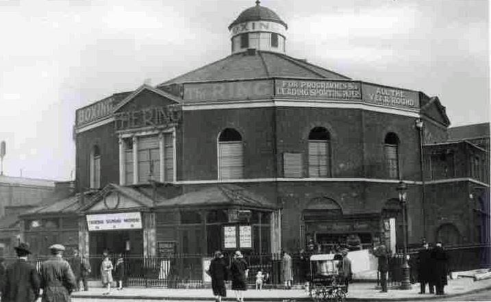
The Ring, Blackfriars Road, SE1 (1925) Although established as a boxing venue in 1910, the building dated from 1783 as the Surrey Congregational Chapel by the Reverend Rowland Hill - who reportedly opted for the unusual, circular design so that there would be no corners in which the devil could hide. The person responsible for overseeing the chapel’s conversion was Dick Burge, a former English middleweight champion from Cheltenham. The former place of worship was then a warehouse. Dick and his wife Bella Burge enlisted the help of local homeless people to clean out the building and transform it into a state fit for presenting boxing to the public. The Ring opened on 14 May 1910, with the Blackfriars arena soon staging events four to five times a week, and the name from the circular shape of the building. The term "boxing ring" is not derived from the name of the building, contrary to local legend, but - still from the capital - instead from the London Prize Ring Rules in 1743, which specified a small circle in the centre of the fight area where the boxers met at the start of each round. The term ’ringside seat’ dates from the 1860s.
Licence: