Area photos
Choose a location
Abbey Road
Abbey Wood
Abridge
Acton
Acton Central
Acton Town
Addington
Addiscombe
Addlestone
Albany Park
Aldgate
Aldgate East
Aldwych
All Saints
Alperton
Amersham
Angel
Archway
Arena
Arkley
Arnos Grove
Arsenal
Aveley
Baker Street
Balham
Bank
Barbican
Barking
Barking Riverside
Barkingside
Barnehurst
Barnes
Barnes Bridge
Barnes Cray
Barnsbury
Barons Court
Batchworth
Battersea
Battersea Park
Battersea Power Station
Bayswater
Becontree
Beddington
Belgravia
Belhus,
Bellingham
Belmont (Middlesex)
Belsize Park
Belvedere
Bermondsey
Berrylands
Bethnal Green
Bexley
Bexleyheath
Bickley
Birkbeck
Blackfriars
Blackheath
Blackhorse Lane
Blackhorse Road
Bloomsbury
Bond Street
Borehamwood
Borough
Boston Manor
Bounds Green
Bow
Bow Church
Bow Road
Bowes Park
Brent Cross
Brent Cross West
Brentford
Bricket Wood
Brixton
Brockley
Brockley Hill
Bromley Common
Bromley North
Bromley South
Bromley-by-Bow
Brompton
Brondesbury
Brondesbury Park
Brooklands
Bruce Grove
Buckhurst Hill
Burgess Park
Burnt Oak
Bushey
Bushey Heath
Byfleet and New Haw
Caledonian Road
Camberwell
Cambridge Heath
Camden Road
Camden Town
Canada Water
Canary Wharf
Canning Town
Cannon Street
Canons Park
Carpenders Park
Catford
Catford Bridge
Chadwell Heath
Chalfont & Latimer
Chalk Farm
Chancery Lane
Chandler’s Cross
Charing Cross
Charlton
Chelsea
Chenies
Chertsey
Chesham
Chevening
Child’s Hill
Chipping Barnet
Chiswick
Chorleywood
City of London
City Thameslink
Clapham Common
Clapham High Street
Clapham Junction
Clapham North
Clapham South
Claremont
Clerkenwell
Clock House
Cockfosters
Colindale
Coombe (Croydon)
Coombe (Kingston)
Corbets Tey
Cottenham Park
Coulsdon
Covent Garden
Cowley
Cranham
Crayford
Crayford Ness
Creekmouth
Cricklewood
Crossharbour
Crouch End
Crouch Hill
Croxley
Croydon
Crystal Palace
Cubitt Town
Cudham
Cutty Sark
Dagenham East
Dagenham Heathway
Dalston
Dalston Junction
Dalston Kingsland
Dancers Hill
Dartford
Debden
Denham
Denmark Hill
Deptford
Devons Road
Dollis Hill
Dormers Wells
Downham
Drayton Green
Drayton Park
Dulwich
Ealing Broadway
Ealing Common
Earl’s Court
Earlsfield
East Acton
East Croydon
East Finchley
East Ham
East Molesey
East Putney
Eastcote
Edgware
Edgware Road
Edgwarebury
Egham Hythe
Elephant and Castle
Elm Park
Elmers End
Elstree
Elstree and Borehamwood
Eltham
Elverson Road
Embankment
Emerson Park
Enfield
Enfield Island Village
Enfield Town
Epping
Epsom
Esher
Essex Road
Euston
Euston Square
Fairlop
Farnborough
Farringdon
Feltham
Fenchurch Street
Finchley Central
Finchley Road
Finchley Road And Frognal
Finsbury Park
Fitzrovia
Force Green
Forest Gate
Forest Hill
Fortis Green
Fortune Green
Friern Barnet
Fulham
Fulham Broadway
Gallions Reach
Gants Hill
Garston
Gloucester Road
Golders Green
Goldhawk Road
Goodge Street
Goodmayes
Gospel Oak
Grahame Park
Gravel Hill
Great Portland Street
Green Park
Greenford
Greenwich
Grove Park
Hacton
Halstead
Ham
Hammersmith
Hampstead
Hampstead Garden Suburb
Hampstead Heath
Hanwell
Harefield
Harlesden
Harmondsworth
Harold Hill
Harold Park
Harringay
Harrow & Wealdstone
Harrow-on-the-Hill
Hatch End
Hatton Cross
Hawley
Hayes (Middlesex)
Hayes and Harlington
Hayes End
Headstone Lane
Heathrow
Heathrow Terminal 5
Hendon
Hendon Central
Herne Hill
Heron Quays
High Street Kensington
Highams Park
Highbury & Islington
Highgate
Hillingdon
Holborn
Holland Park
Holloway Road
Honor Oak
Hornchurch
Hounslow East
Hounslow West
Hoxton
Hyde Park Corner
Ickenham
Imperial Wharf
Island Gardens
Islington
Joyden’s Wood
Kennington
Kensal Green
Kensal Rise
Kensal Town
Kensington
Kensington (Olympia)
Kentish Town
Kentish Town West
Kenton
Keston
Kew Green
Kilburn
Kilburn High Road
Kilburn Park
King’s Cross St Pancras
Kingsbury
Knightsbridge
Knockholt
Ladbroke Grove
Laleham
Lambeth
Lambeth North
Lancaster Gate
Langdon Park
Latimer
Latimer Road
Lavender Hill
Lea Bridge
Leicester Square
Letchmore Heath
Lewisham
Leytonstone
Limehouse
Little Chalfont
Little Ilford
Little Venice
Liverpool Street
Lloyd Park
London Bridge
London City Airport
Loughton
Maida Hill
Maida Vale
Malden Manor
Malden Rushett
Manor House
Mansion House
Maple Cross
Marble Arch
Marylebone
Mayfair
Maze Hill
Meridian Water
Mertsham
Mile End
Mill Hill
Mill Hill Broadway
Mill Hill East
Millwall
Mitcham
Mitcham Eastfields
Monken Hadley
Monks Orchard
Monument
Moor Park
Moorgate
Morden
Mornington Crescent
Mortlake
Mudchute
Muswell Hill
Neasden
New Addington
New Cross Gate
New Haw
New Southgate
Nine Elms
North Acton
North Dulwich
North End
North Finchley
North Greenwich
North Harrow
North Kensington
North Ockendon
North Wembley
North Woolwich
Northfields
Northwick Park
Northwood
Norwood Green
Notting Dale
Notting Hill
Notting Hill Gate
Nunhead
Oakwood
Old Street
Orpington
Osidge
Oval
Oxford Circus
Paddington
Parsons Green
Peckham
Peckham Rye
Penton Park
Pentonville
Perivale
Petersham
Piccadilly Circus
Pimlico
Plaistow
Plumstead
Pollards Hill
Pontoon Dock
Pooley Green
Poplar
Poyle
Preston Road
Pudding Mill Lane
Purfleet
Purley Oaks
Putney
Putney Bridge
Queens Park Estate
Queens Road Peckham
Queensbury
Queensmead
Queenstown Road
Queensway
Queen’s Park
Radlett
Rainham
Ravenscourt Park
Rayners Lane
Reeves Corner
Regent’s Park
Richmond
Rickmansworth
Ridge
Rippleside
Roding Valley
Roehampton
Romford
Rotherhithe
Roxeth
Royal Oak
Ruislip
Ruislip Common
Ruislip Gardens
Ruislip Manor
Russell Square
Sandilands
Scratchwood
Scrattons Farm,
Selsdon
Seven Sisters
Sewardstone
Sewardstonebury
Shadwell
Shenley
Shepherd’s Bush Market
Shepherds Bush
Shepperton
Shoreditch
Silvertown
Sipson
Slade Green
Sloane Square
Snaresbrook
Soho
Somers Town
South Acton
South Ealing
South End Green
South Harrow
South Kensington
South Kenton
South Lambeth
South Mimms
South Oxhey
South Ruislip
South Wimbledon
South Woodford
Southall
Southfields
Southgate
Southwark
Spitalfields
Spring Park
St George’s Hill
St Giles
St James’s
St James’s Park
St John’s Wood
St Pancras
St Paul’s
Staines
Stamford Brook
Stamford Hill
Stanmore
Stapleford Abbots
Stepney Green
Stockwell
Stoke D’Abernon
Stoke Newington
Stonebridge
Stonebridge Park
Stratford
Stratford High Street
Stratford International
Streatham
Streatham Vale
Sudbury Hill
Sudbury Town
Surbiton
Swanley
Swiss Cottage
Tadworth
Tatsfield
Teddington
Temple
Temple Fortune
Temple Park
Thamesmead
The Underground Map
Theydon Bois
Thorpe
Thorpe Lea
Tottenham Court Road
Totteridge
Totteridge And Whetstone
Tower Gateway
Tower Hill
Tufnell Park
Tulse Hill
Turnham Green
Turnpike Lane
Underhill
Upminster
Upminster Bridge
Upney
Upper Holloway
Upton Park
Uxbridge
Vauxhall
Victoria
Victoria Park
Walford
Walthamstow Central
Walworth
Wandsworth
Wandsworth Road
Wanstead
Wapping
Warlingham
Warren Street
Warwick Avenue
Waterloo
Watford
Watford High Street
Watford Junction
Wealdstone
Welling
Wembley Central
Wembley Park
West Acton
West Bedfont
West Brompton
West Croydon
West Drayton
West Ealing
West Ham
West Hampstead
West Harrow
West Hendon
West India Quay
West Kensington
West Kilburn
West Ruislip
Westbourne Green
Westbourne Park
Westcombe Park
Westminster
Weybridge
Whetstone
Whipps Cross
White City
White Hart Lane
Whitechapel
Whiteley Village
Willesden
Willesden Green
Willesden Junction
Wimbledon
Wimbledon Park
Winchmore Hill
Wood Green
Wood Lane
Woodford
Woodford Green
Woodmansterne
Woodside
Woodside Park
Woolwich
Yeading
Yiewsley
HOME
·
ARTICLE
·
MAPS
·
STREETS
·
BLOG
·
CONTACT US
(51.5392 0.04703, 51.539 0.047)
20171113:3
LOCAL PHOTOS
Click here to see map view of nearby Creative Commons images
Click here to see Creative Commons images near to this postcode
Click here to see Creative Commons images tagged with this road (if applicable)
The Premier Cinema, East Ham (1936) The cinema was renamed the Gaumont in 1952 and closed as a cinema in 1963. It reopened as a Top Rank Club for bingo, later renamed Mecca, which closed in 2005. In spite of being a fine example of an early cinema, it was never designated listed status and was demolished in 2009.
Credit: John Maltby
TUM image id:
1630689466
Licence:
Upton Park (1929)
TUM image id:
1660665194
Licence:
Boleyn Tavern (2009) The Boleyn Tavern is a Victorian pub building near to the Boleyn Ground, the former football ground of West Ham United.
Credit: Ewan Munro
TUM image id:
1630685206
Licence:
The Boleyn Electric Theatre, Barking Road, E13 (1937) The photo was taken immediatelty prior to the cinema’s demolition and reopening as the East Ham Odeon.
Credit: John Maltby
TUM image id:
1630671295
Licence:
High Street North, E6 The road has been the main shopping street for East Ham since the nineteenth century.
TUM image id:
1630690544
Licence:
London in 2020 was a radically different place compared with the London of other years.
Credit: Matt
TUM image id:
1609176729
Licence: CC BY 2.0
A view of Egypt and the eastern Mediterranean from orbit
Credit: Eumetsat
TUM image id:
1609177627
Licence:
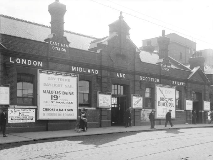
East Ham station (1928) Trips to France from St Pancras have a history!
TUM image id:
1683193209
Licence:
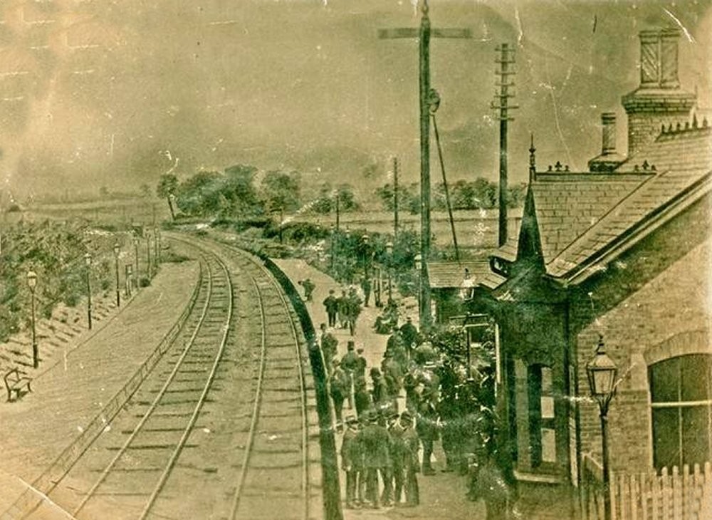
East Ham - a small country station among green fields (1900) In 1858 the London, Tilbury and Southend Railway opened its line from Bow to Barking with stations at Plaistow Road and at East Ham. The engineer was George Parker Bidder and Samuel Morton Peto was the contractor. Other stations were built at Upton Park (1877) and West Ham (Manor Road) in 1901. This view looks towards Barking. Originally, there had been a level crossing carrying the High Street across the two tracks. Sibley Grove (formerly Jews Farm Lane) would be to the left and what was to became Burges, Southend and Stevenage Roads are yet to be built on the south side. Originally, there had been a level crossing at the Upton Park end of the platforms, where the tracks crossed White Post Lane. As East Ham developed and traffic increased, a road bridge was built. The Lane was renamed High Street North.
TUM image id:
1660579198
Licence:
Pearly children (1913) Charity work and costumes covered with ’flashies’ have remained central to the role of the Pearlies, though their visibility has diminished in the 21st century
TUM image id:
1630624880
Licence:
For those of us who are confused by coffee...
TUM image id:
1630624684
Licence:
In the neighbourhood...
Click an image below for a better view...
The Premier Cinema, East Ham (1936) The cinema was renamed the Gaumont in 1952 and closed as a cinema in 1963. It reopened as a Top Rank Club for bingo, later renamed Mecca, which closed in 2005. In spite of being a fine example of an early cinema, it was never designated listed status and was demolished in 2009.
Credit: John Maltby
Licence:
High Street North, E6 The road has been the main shopping street for East Ham since the nineteenth century.
Licence:
East Ham station (1928) Trips to France from St Pancras have a history!
Licence:
For those of us who are confused by coffee...
Licence: