Area photos
Choose a location
Abbey Road
Abbey Wood
Abridge
Acton
Acton Central
Acton Town
Addington
Addiscombe
Addlestone
Albany Park
Aldgate
Aldgate East
Aldwych
All Saints
Alperton
Amersham
Angel
Archway
Arena
Arkley
Arnos Grove
Arsenal
Aveley
Baker Street
Balham
Bank
Barbican
Barking
Barking Riverside
Barkingside
Barnehurst
Barnes
Barnes Bridge
Barnes Cray
Barnsbury
Barons Court
Batchworth
Battersea
Battersea Park
Battersea Power Station
Bayswater
Becontree
Beddington
Belgravia
Belhus,
Bellingham
Belmont (Middlesex)
Belsize Park
Belvedere
Bermondsey
Berrylands
Bethnal Green
Bexley
Bexleyheath
Bickley
Birkbeck
Blackfriars
Blackheath
Blackhorse Lane
Blackhorse Road
Bloomsbury
Bond Street
Borehamwood
Borough
Boston Manor
Bounds Green
Bow
Bow Church
Bow Road
Bowes Park
Brent Cross
Brent Cross West
Brentford
Bricket Wood
Brixton
Brockley
Brockley Hill
Bromley Common
Bromley North
Bromley South
Bromley-by-Bow
Brompton
Brondesbury
Brondesbury Park
Brooklands
Bruce Grove
Buckhurst Hill
Burgess Park
Burnt Oak
Bushey
Bushey Heath
Byfleet and New Haw
Caledonian Road
Camberwell
Cambridge Heath
Camden Road
Camden Town
Canada Water
Canary Wharf
Canning Town
Cannon Street
Canons Park
Carpenders Park
Catford
Catford Bridge
Chadwell Heath
Chalfont & Latimer
Chalk Farm
Chancery Lane
Chandler’s Cross
Charing Cross
Charlton
Chelsea
Chenies
Chertsey
Chesham
Chevening
Child’s Hill
Chipping Barnet
Chiswick
Chorleywood
City of London
City Thameslink
Clapham Common
Clapham High Street
Clapham Junction
Clapham North
Clapham South
Claremont
Clerkenwell
Clock House
Cockfosters
Colindale
Coombe (Croydon)
Coombe (Kingston)
Corbets Tey
Cottenham Park
Coulsdon
Covent Garden
Cowley
Cranham
Crayford
Crayford Ness
Creekmouth
Cricklewood
Crossharbour
Crouch End
Crouch Hill
Croxley
Croydon
Crystal Palace
Cubitt Town
Cudham
Cutty Sark
Dagenham East
Dagenham Heathway
Dalston
Dalston Junction
Dalston Kingsland
Dancers Hill
Dartford
Debden
Denham
Denmark Hill
Deptford
Devons Road
Dollis Hill
Dormers Wells
Downham
Drayton Green
Drayton Park
Dulwich
Ealing Broadway
Ealing Common
Earl’s Court
Earlsfield
East Acton
East Croydon
East Finchley
East Ham
East Molesey
East Putney
Eastcote
Edgware
Edgware Road
Edgwarebury
Egham Hythe
Elephant and Castle
Elm Park
Elmers End
Elstree
Elstree and Borehamwood
Eltham
Elverson Road
Embankment
Emerson Park
Enfield
Enfield Island Village
Enfield Town
Epping
Epsom
Esher
Essex Road
Euston
Euston Square
Fairlop
Farnborough
Farringdon
Feltham
Fenchurch Street
Finchley Central
Finchley Road
Finchley Road And Frognal
Finsbury Park
Fitzrovia
Force Green
Forest Gate
Forest Hill
Fortis Green
Fortune Green
Friern Barnet
Fulham
Fulham Broadway
Gallions Reach
Gants Hill
Garston
Gloucester Road
Golders Green
Goldhawk Road
Goodge Street
Goodmayes
Gospel Oak
Grahame Park
Gravel Hill
Great Portland Street
Green Park
Greenford
Greenwich
Grove Park
Hacton
Halstead
Ham
Hammersmith
Hampstead
Hampstead Garden Suburb
Hampstead Heath
Hanwell
Harefield
Harlesden
Harmondsworth
Harold Hill
Harold Park
Harringay
Harrow & Wealdstone
Harrow-on-the-Hill
Hatch End
Hatton Cross
Hawley
Hayes (Middlesex)
Hayes and Harlington
Hayes End
Headstone Lane
Heathrow
Heathrow Terminal 5
Hendon
Hendon Central
Herne Hill
Heron Quays
High Street Kensington
Highams Park
Highbury & Islington
Highgate
Hillingdon
Holborn
Holland Park
Holloway Road
Honor Oak
Hornchurch
Hounslow East
Hounslow West
Hoxton
Hyde Park Corner
Ickenham
Imperial Wharf
Island Gardens
Islington
Joyden’s Wood
Kennington
Kensal Green
Kensal Rise
Kensal Town
Kensington
Kensington (Olympia)
Kentish Town
Kentish Town West
Kenton
Keston
Kew Green
Kilburn
Kilburn High Road
Kilburn Park
King’s Cross St Pancras
Kingsbury
Knightsbridge
Knockholt
Ladbroke Grove
Laleham
Lambeth
Lambeth North
Lancaster Gate
Langdon Park
Latimer
Latimer Road
Lavender Hill
Lea Bridge
Leicester Square
Letchmore Heath
Lewisham
Leytonstone
Limehouse
Little Chalfont
Little Ilford
Little Venice
Liverpool Street
Lloyd Park
London Bridge
London City Airport
Loughton
Maida Hill
Maida Vale
Malden Manor
Malden Rushett
Manor House
Mansion House
Maple Cross
Marble Arch
Marylebone
Mayfair
Maze Hill
Meridian Water
Mertsham
Mile End
Mill Hill
Mill Hill Broadway
Mill Hill East
Millwall
Mitcham
Mitcham Eastfields
Monken Hadley
Monks Orchard
Monument
Moor Park
Moorgate
Morden
Mornington Crescent
Mortlake
Mudchute
Muswell Hill
Neasden
New Addington
New Cross Gate
New Haw
New Southgate
Nine Elms
North Acton
North Dulwich
North End
North Finchley
North Greenwich
North Harrow
North Kensington
North Ockendon
North Wembley
North Woolwich
Northfields
Northwick Park
Northwood
Norwood Green
Notting Dale
Notting Hill
Notting Hill Gate
Nunhead
Oakwood
Old Street
Orpington
Osidge
Oval
Oxford Circus
Paddington
Parsons Green
Peckham
Peckham Rye
Penton Park
Pentonville
Perivale
Petersham
Piccadilly Circus
Pimlico
Plaistow
Plumstead
Pollards Hill
Pontoon Dock
Pooley Green
Poplar
Poyle
Preston Road
Pudding Mill Lane
Purfleet
Purley Oaks
Putney
Putney Bridge
Queens Park Estate
Queens Road Peckham
Queensbury
Queensmead
Queenstown Road
Queensway
Queen’s Park
Radlett
Rainham
Ravenscourt Park
Rayners Lane
Reeves Corner
Regent’s Park
Richmond
Rickmansworth
Ridge
Rippleside
Roding Valley
Roehampton
Romford
Rotherhithe
Roxeth
Royal Oak
Ruislip
Ruislip Common
Ruislip Gardens
Ruislip Manor
Russell Square
Sandilands
Scratchwood
Scrattons Farm,
Selsdon
Seven Sisters
Sewardstone
Sewardstonebury
Shadwell
Shenley
Shepherd’s Bush Market
Shepherds Bush
Shepperton
Shoreditch
Silvertown
Sipson
Slade Green
Sloane Square
Snaresbrook
Soho
Somers Town
South Acton
South Ealing
South End Green
South Harrow
South Kensington
South Kenton
South Lambeth
South Mimms
South Oxhey
South Ruislip
South Wimbledon
South Woodford
Southall
Southfields
Southgate
Southwark
Spitalfields
Spring Park
St George’s Hill
St Giles
St James’s
St James’s Park
St John’s Wood
St Pancras
St Paul’s
Staines
Stamford Brook
Stamford Hill
Stanmore
Stapleford Abbots
Stepney Green
Stockwell
Stoke D’Abernon
Stoke Newington
Stonebridge
Stonebridge Park
Stratford
Stratford High Street
Stratford International
Streatham
Streatham Vale
Sudbury Hill
Sudbury Town
Surbiton
Swanley
Swiss Cottage
Tadworth
Tatsfield
Teddington
Temple
Temple Fortune
Temple Park
Thamesmead
The Underground Map
Theydon Bois
Thorpe
Thorpe Lea
Tottenham Court Road
Totteridge
Totteridge And Whetstone
Tower Gateway
Tower Hill
Tufnell Park
Tulse Hill
Turnham Green
Turnpike Lane
Underhill
Upminster
Upminster Bridge
Upney
Upper Holloway
Upton Park
Uxbridge
Vauxhall
Victoria
Victoria Park
Walford
Walthamstow Central
Walworth
Wandsworth
Wandsworth Road
Wanstead
Wapping
Warlingham
Warren Street
Warwick Avenue
Waterloo
Watford
Watford High Street
Watford Junction
Wealdstone
Welling
Wembley Central
Wembley Park
West Acton
West Bedfont
West Brompton
West Croydon
West Drayton
West Ealing
West Ham
West Hampstead
West Harrow
West Hendon
West India Quay
West Kensington
West Kilburn
West Ruislip
Westbourne Green
Westbourne Park
Westcombe Park
Westminster
Weybridge
Whetstone
Whipps Cross
White City
White Hart Lane
Whitechapel
Whiteley Village
Willesden
Willesden Green
Willesden Junction
Wimbledon
Wimbledon Park
Winchmore Hill
Wood Green
Wood Lane
Woodford
Woodford Green
Woodmansterne
Woodside
Woodside Park
Woolwich
Yeading
Yiewsley
HOME
·
ARTICLE
·
MAPS
·
STREETS
·
BLOG
·
CONTACT US
(51.52414 -0.14932, 51.524 -0.149)
20000101:9
LOCAL PHOTOS
Click here to see map view of nearby Creative Commons images
Click here to see Creative Commons images near to this postcode
Click here to see Creative Commons images tagged with this road (if applicable)
Montagu House, Portman Square
TUM image id:
1510140427
Licence: CC BY 2.0
Metropolitan Borough of St Marylebone coat of arms
TUM image id:
1585912333
Licence: CC BY 2.0
Baker Street station (1890) This viewpoint shows a busy yet narrow Marylebone Road. We are looking east along the road. Chiltern Court is not yet built which will come to dominate the left of the view. The spire of Marylebone church can be seen in the distance on the right.
Credit: Bishopsgate Institute
TUM image id:
1557150556
Licence:
High level shot of Regents Place as seen from Great Portland Street. The photograph shows the Holy Trinity Church and Great Portland Street underground station in the foreground.
Credit: Wiki Commons/PortlandVillage
TUM image id:
1674220898
Licence: CC BY 2.0
The Carreras Cigarette factory, Mornington Crescent area This started life at the Acadia Works on City Road in the 19th century. It was a small business owned by Don Jose Carreras Ferrer who sold cigarettes, cigars and snuff out of small shops. A black cat began to curl up and sleep in the window of the shop near Leicester Square in Prince’s Street and the shop became known locally as "The Black Cat Shop". After the cigarette making machine was invented, the business required a large factory and moved to Hampstead Road between 1926 and 1928. It was designed by architect brothers, Marcus and Owen Collins with George Porri as their consultant. The black cat became the company’s logo. In 1959 the company merged with Rothmans and moved to Basildon, Essex. In the early 1960s the building became offices. The Egyptian décor was stripped away and the two cat statues removed. When the building got new owners in 1996, its former grandeur was restored. The building was later called “Greater London House” having become an office building.
TUM image id:
1660650534
Licence: CC BY 2.0
64 Baker Street, photographed in 2021.
Credit: Wiki Commons/Kyle Glover
TUM image id:
1674550415
Licence: CC BY 2.0
Block of flats on the Regent’s Park Estate (2009) A large housing estate in the London Borough of Camden built after 1951, most of the estate is named after places in the Lake District such as Windermere, Cartmel and Rydal Water.
Credit: Wiki Commons/Sheila Madhvani
TUM image id:
1656943297
Licence: CC BY 2.0
Beaumont Street (2014)
Credit: Philafrenzy/Wiki Commons
TUM image id:
1596551507
Licence: CC BY 2.0
View South of Hallam Street, near Weymouth House (2008)
Credit: Wiki Commons/Portlandvillage
TUM image id:
1658789918
Licence: CC BY 2.0
Jason Court W1
Credit: The Underground Map
TUM image id:
1526076132
Licence: CC BY 2.0
Mornington Crescent, northwest quadrant (1904). The view includes no.31 where Spencer Gore rented a room between 1909–12.
Credit: Camden Local Studies and Archives Centre
TUM image id:
1543348539
Licence: CC BY 2.0
Picton Place, W1 was formerly Gray Street as can be seen on a ’ghost sign’ on the corner
Credit: Simon Gunzinger
TUM image id:
1653863025
Licence:
Portman Square, W1H
TUM image id:
1510141130
Licence: CC BY 2.0
A 2500 pound German bomb, buried opposite University College Hospital, is about to be removed by Army sappers as people in the area are evacuated to a safe distance (1948) Metropolitan "C’ Division covered the West End. Note the ’on duty’ striped armbands and the black helmet plates (now silver). The bomb fell in 1941 near to the corner of Stanhope Street and Euston Road.
Credit: Creative Commons image from New Times Paris Bureau Collection
TUM image id:
1652572724
Licence:
Warren Mews (2022) It is a cobbled cul-de-sac approached through an entrance under a building on Warren Street, in line with Fitzroy Mews.
Credit: @sarah.tuckman
TUM image id:
1657139677
Licence:
In the neighbourhood...
Click an image below for a better view...
64 Baker Street, photographed in 2021.
Credit: Wiki Commons/Kyle Glover
Licence: CC BY 2.0
Beaumont Street (2014)
Credit: Philafrenzy/Wiki Commons
Licence: CC BY 2.0
View South of Hallam Street, near Weymouth House (2008)
Credit: Wiki Commons/Portlandvillage
Licence: CC BY 2.0
Grotto Passage
Credit: Wiki Commons
Licence: CC BY 2.0
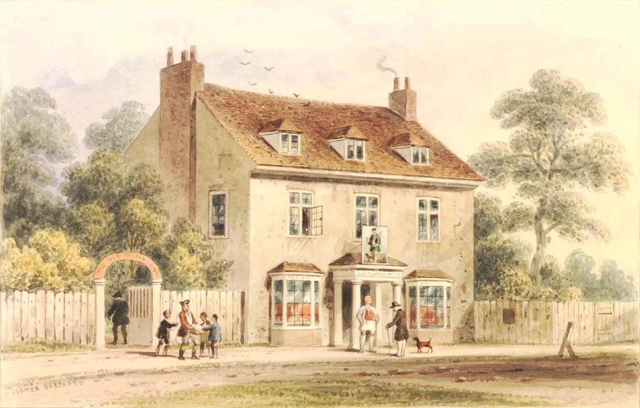
The Farthing Pye House in 1780, painted in watercolour by Thomas H. Shepherd. This morphed into the Greene Man, on the Euston Road opposite Great Portland Street station. It was called the Farthing Pye House as mutton pies could be bought there for a farthing. The pub is now owned by Greene King who changed the spelling of the sign to match their branding, when they took over the Spirit Pub Company in 2015 and retired the Taylor Walker brewery brand. In 2019, the cheapest pie on the menu was ascertained to be the Woodland Mushroom & Ale which cost £10.99. As there were 960 farthings in a pound sterling, the nominal price of a pie there has risen by a factor of over 10000.
Credit: Thomas H. Shepherd
Licence:
Great Portland Street roundel
Licence:
Drawing of Baker Street Bakerloo Line platforms (1906)
Licence:
"Thomas Milne’s Land Use Map of London and Environs in 1800" built upon work by the cartographer between 1795 and 1799. It provides an unique and rare glimpse into the land usage in London during that time. What sets Milne’s map apart from its predecessors is not only its ambitious scope and accurate information but also its innovative presentation. Using a colour code and lettering system, Milne effectively distinguishes between twelve different land-use categories, resulting in an unparalleled depiction of London and its surrounding areas during a period of rapid transformation. On this section in particular, we can see the line of the New Road (Marylebone Road and Euston Road) in its attempt to curtail the northern growth of the capital. The footprint of the then-future Regent’s Park is evident. Over on the right side of the map, Battle Bridge - still surrounded by fields - will be the future King’s Cross
Credit: Thomas Milne (public domain)
Licence:
Regent’s Park in 1820 Regent’s Park was laid out between 1818 and 1835. This map shows it as a ’work in progress’. The Waterloo monument didn’t turn out to be the major feature that had been proposed. The park overtook the planned streets around Cumberland Market.
Licence: