Charlton

Rail station, existing between 1849 and now.

 HOME  ·  ARTICLE  ·  MAPS  ·  STREETS  ·  BLOG  ·  CONTACT US 
(51.487 0.031, 51.487 0.031) 
MAP YEAR:175018001810182018301860190019502024Show map without markers
Use the control in the top right of the map above to view this area on another historic map
 
Rail station · * · SE7 ·
JANUARY
3
2023
’Charlton next Woolwich’ was an ancient parish in the county of Kent, which became part of the metropolitan area of London in 1855.

The parish of Charlton is first recorded in the 1086 Domesday Book as Cerletone, meaning "farmstead of the freemen or peasants" in Old English. In 1093, the manor was granted to Bermondsey Abbey by the Bishop of Lincoln. In 1268, the Abbey obtained rights to hold a market and fair in Charlton. In the early 1700s, Daniel Defoe described Charlton’s notorious annual Horn Fair. The North Kent railway line reached Charlton in 1849.

Aside from the modern Thames Barrier and The Valley stadium, Charlton’s most notable landmark is Jacobean Charlton House, built in 1607-1612 for tutor to Prince Henry, Adam Newton. Nearby St. Luke’s Church is the burial site of Prime Minister Spencer Perceval and civil servant Edward Drummond. Charlton House became home to the Maryon-Wilson family, namesakes of two local parks. Since 1925, the Royal Borough of Greenwich has owned Charlton House, now a library and community centre.

With its parks, historic homes and transportation links, Charlton has evolved into a diverse London suburb attracting commuters. Long-time residents mix with young professionals and various ethnic groups. Nearby North Greenwich tube station provides easy access to Canary Wharf.

Charlton is home to Charlton Athletic Football Club.

The area has been settled at least since the early Roman period; a Romano-British fort on Cox’s Mount (now  part of Maryon Park) was excavated in 1913, revealing finds dating from 60 AD through to the 4th century. The name Charlton is of Saxon origin, compounded of ceorl (=churl), referring to a small peasant farmer, and tūn, a settlement or farmstead. After 1066 the manor of Charlton was granted by William I to his half-brother Odo, Bishop of Bayeux, passing into the ownership of Bermondsey Abbey in 1093. The first record of a church at Charlton comes in 1077, while the Domesday survey of 1086 records a medium-sized village of 15 households with farmland amounting to 1 sulung (notionally equivalent to 240 acres) and valued at 7 pounds. The medieval parish of Charlton, part of the ancient hundred of Blackheath in the county of Kent, stretched all the way from Woolwich Common in the east to what is now Blackheath Village in the west; it was formerly known as Charlton-next-Woolwich to distinguish it from its east Kent namesake Charlton-by-Dover.


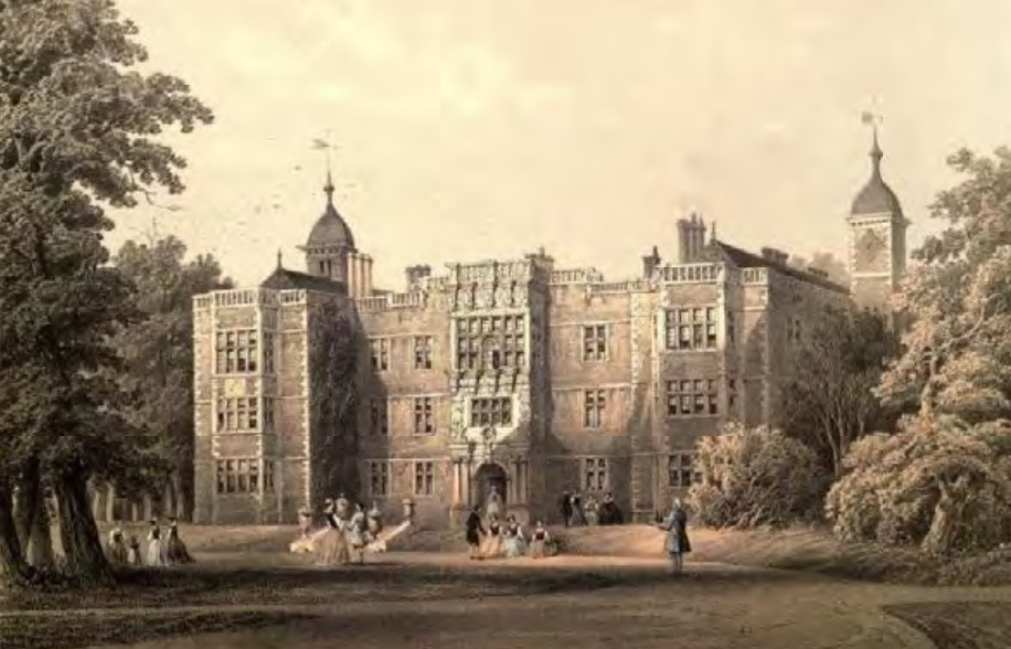
Lithograph of 1858 by James Holland, showing the west front of Charlton House
(click image to enlarge)


Market rights were granted by Henry III in 1268, as well as an annual fair. The latter had mutated by the 17th century into the institution of the ‘Horn Fair’, a popular spree held on the village green each St Luke’s Day (October 18th), preceding which large crowds of celebrants – elaborately costumed, often in drag – would process from Rotherhithe to Charlton, wearing horned head-dresses and playing upon ram’s-horn trumpets. Like others of its kind around the country, the Horn Fair – associated in local legend with a supposed sexual encounter between King John and the wife of a Charlton miller – was notoriously unruly; Daniel Defoe, writing in the 1720s in his Tour through the Whole Island of Great Britain, decried ‘the yearly collected rabble of mad-people at Horn-Fair, the rudeness of which, I cannot but think, is such as ought to be suppressed’. Daniel Lysons (The Environs of London, vol. 4, 1796) reports that the procession was discontinued in 1768, though the fair itself apparently survived for another hundred years, eventually being suppressed under the terms of the 1871 Fairs Act. A version of the Horn Fair was revived in the 1970s and continues today.

The manor, having reverted to the Crown at the Reformation, was acquired in 1606 by Sir Adam Newton, tutor and secretary to Henry, Prince of Wales. Newton was responsible for building the present Charlton House – the finest Jacobean mansion now surviving in London – between 1607 and 1612. St Luke, ‘a most attractive church in its humble, pre-classical character’ (as Pevsner and Cherry state in the volume on South London) also dates mainly from this period, since the provisions of Newton’s will allowed for the complete rebuilding of the Church in 1630-40. Other buildings remaining from this era include the stables, park wall and garden house – the latter a very early example of English Palladianism, traditionally (though without written evidence) attributed to Inigo Jones.

The 18th and early 19th centuries witnessed comparatively little change. John Rocque’s map of 1746 clearly shows the nucleus of the village, with Charlton House (called ‘Charlton Place’) and its park to the south, a scattering of houses further west along Charlton Road, and Hanging Wood, still at its full 150-acre extent, to the north-east. Twenty years later, in 1767, the Charlton estate passed into the ownership of the Maryon Wilson family, who would remain lords of the manor until the 1920s.

A series of drawings dating from the 1820s show Charlton still in its post-medieval aspect, with timber-framed buildings clustered along the muddy village street against a background of fields and woods. The village green, still visible in these drawings, was incorporated into the grounds of Charlton House in 1829.


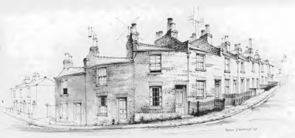
Nos. 2-18 Lansdowne Lane built 1862-3, drawn by Falcon Hildred in 1967 prior to their demolition in 1968 © Crown copyright: Royal Commission on the Ancient and Historical Monuments of Wales
(click image to enlarge)


This period did witness the first phase of ‘suburban’ development, with several large detached villas built for members of the ‘carriage classes’, for whom Charlton, with its fresh air, panoramic views and good road connections, made a pleasant commuting base or weekend retreat. (The house formerly known as The Warren, now 78 Charlton Church Lane, is probably an example.)

The major impetus for suburbanisation came in 1849, however, when the South-Eastern Railway extended its North Kent Line from Gravesend through to London Bridge, with a station at the bottom of Charlton Church Lane. This had the double effect of stimulating rapid industrial growth in the riverside area – henceforth known as New Charlton – and encouraging suburban development around the old village. Residential growth was slow at first: groups of large villas were built in Charlton Church Lane and Victoria Way, with smaller cottages in Charlton Lane, Lansdowne Lane and Fairfield Grove.

A series of drawings made by the artist Falcon Hildred in the 1960s record a row of terraced cottages in Lansdowne Lane prior to their demolition in 1968 to make way for flats (now 1a Fletching Road). The detailed plans, elevations and elevated perspectives show that Nos. 2-18 comprised typical ‘two-up-two-down’ terraced houses with narrow street frontages, built on narrow tapering plots, with no bathrooms, only toilets housed in outbuildings to the rear. These drawings are an important record of humble, high-density workers housing, once so prevalent in mid- to late-19th century London, but which has rarely survived post-war redevelopment.

A remnant of this housing does in fact survive a little further to the north on Lansdowne Lane: Nos. 26-28, a pair of cottages, curiously set back some distance from the lane so that they are easily overlooked.


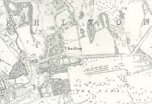
Ordnance Survey map of 1867 showing Charlton village and park, with early residential development on
Lansdowne Lane and Fairfield Grove
(click image to enlarge)


The increase in population prompted the laying-out of Charlton Cemetery in 1855, and the building of two new parish churches: St Thomas, Maryon Road (1849-50) and St Paul, Fairfield Grove (1867, now demolished). The Metropolitan Board of Works, whose sphere of authority stretched as far out as Woolwich, built imposing new premises (now demolished) on the south side of The Village. Nevertheless, as late as 1878 Edward Walford’s Old and New London could describe Charlton as ‘a pretty little village…still green and pleasant’ despite ‘the gradual extension of buildings’.

Large-scale expansion, joining Charlton up with Woolwich in the east and Blackheath in the west, came around the turn of the century, when Heathwood and (later) Kinveachy Gardens were built over part of Hanging Wood, and Elliscombe Road and its neighbours were laid out in the combes and sand-pits to the west. The core of the medieval village was largely rebuilt at this period, with the old timber-framed houses (of which the Bugle Horn Inn is now the only – much altered – survivor) giving way to brick-built Victorian commercial premises, comprising more than 20 shops including a fruiterer, a fishmonger, a bootmaker, a watchmaker, two drapers and two bakers, according to the 1881 census.

Charlton’s transformation from village to suburb was confirmed by its inclusion, after the local government reforms of the 1880s and 90s, within the purview of the newly-formed London County Council (LCC) and Metropolitan Borough of Greenwich.


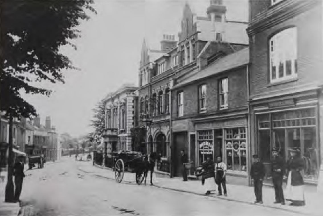
Postcard of 1915 showing the south side of The Village, including the White Swan PH
(click image to enlarge)


Main source: Wikipedia
Further citations and sources


CONTRIBUTIONS TO THE LOCALITY

None so far :(
LATEST LONDON-WIDE CONTRIBUTIONS TO THE PROJECT

Comment
   
Added: 2 May 2024 16:14 GMT   

Farm Place, W8
The previous name of Farm Place was Ernest St (no A)

Reply
Comment
Tony Whipple   
Added: 16 Apr 2024 21:35 GMT   

Frank Whipple Place, E14
Frank was my great-uncle, I’d often be ’babysat’ by Peggy while Nan and Dad went to the pub. Peggy was a marvel, so full of life. My Dad and Frank didn’t agree on most politics but everyone in the family is proud of him. A genuinely nice, knowledgable bloke. One of a kind.

Reply
Comment
Theresa Penney   
Added: 16 Apr 2024 18:08 GMT   

1 Whites Row
My 2 x great grandparents and his family lived here according to the 1841 census. They were Dutch Ashkenazi Jews born in Amsterdam at the beginning of the 19th century but all their children were born in Spitalfields.

Reply
Comment
Wendy    
Added: 22 Mar 2024 15:33 GMT   

Polygon Buildings
Following the demolition of the Polygon, and prior to the construction of Oakshott Court in 1974, 4 tenement type blocks of flats were built on the site at Clarendon Sq/Phoenix Rd called Polygon Buildings. These were primarily for people working for the Midland Railway and subsequently British Rail. My family lived for 5 years in Block C in the 1950s. It seems that very few photos exist of these buildings.

Reply

Steve   
Added: 19 Mar 2024 08:42 GMT   

Road construction and houses completed
New Charleville Circus road layout shown on Stanford’s Library Map Of London And Its Suburbs 1879 with access via West Hill only.

Plans showing street numbering were recorded in 1888 so we can concluded the houses in Charleville Circus were built by this date.

Source: Charleville Circus, Sydenham, London

Reply
Comment
Steve   
Added: 19 Mar 2024 08:04 GMT   

Charleville Circus, Sydenham: One Place Study (OPS)
One Place Study’s (OPS) are a recent innovation to research and record historical facts/events/people focused on a single place �’ building, street, town etc.

I have created an open access OPS of Charleville Circus on WikiTree that has over a million members across the globe working on a single family tree for everyone to enjoy, for free, forever.

Source: Charleville Circus, Sydenham, London

Reply
Comment
Charles   
Added: 8 Mar 2024 20:45 GMT   

My House
I want to know who lived in my house in the 1860’s.

Reply

NH   
Added: 7 Mar 2024 11:41 GMT   

Telephone House
Donald Hunter House, formerly Telephone House, was the BT Offices closed in 2000

Reply


NEARBY LOCATIONS OF NOTE
Charlton ’Charlton next Woolwich’ was an ancient parish in the county of Kent, which became part of the metropolitan area of London in 1855.

NEARBY STREETS
Anchor And Hope Lane, SE7 Anchor And Hope Lane is one of the streets of London in the SE7 postal area (Charlton)
Anchor and Hope Lane, SE7 Anchor Hope Lane is a road leading to the riverside in Woolwich (Charlton)
Atlas Gardens, SE7 Atlas Gardens is a road in the SE7 postcode area (Charlton)
Banchory Road, SE3 Banchory Road is one of the streets of London in the SE3 postal area (Charlton)
Barney Close, SE7 Barney Close is one of the streets of London in the SE7 postal area (Charlton)
Beacham Close, SE7 Beacham Close is one of the streets of London in the SE7 postal area (Charlton)
Bernard Ashley Drive, SE7 Bernard Ashley Drive is a road in the SE7 postcode area (Charlton)
Birch Tree Court, SE7 Birch Tree Court is a road in the SE7 postcode area (Charlton)
Blackwall Tunnel Approach, SE3 Blackwall Tunnel Approach is a road in the SE3 postcode area (Charlton)
Blaker Court, SE7 Blaker Court is a block on Blaker Court (Charlton)
Bowen Drive, SE7 Bowen Drive is a location in London (Charlton)
Bramhope Lane, SE7 Bramhope Lane is one of the streets of London in the SE7 postal area (Charlton)
Bramshot Avenue, SE7 Bramshot Avenue is one of the streets of London in the SE7 postal area (Charlton)
Bramshot Road, SE7 Bramshot Road is a road in the SE7 postcode area (Charlton)
Brocklebank Road, SE7 Brocklebank Road is one of the streets of London in the SE7 postal area (Charlton)
Bugsbys Way, SE7 Bugsbys Way is one of the streets of London in the SE7 postal area (Charlton)
Calydon Road, SE7 Calydon Road is a road in the SE7 postcode area (Charlton)
Canberra Road, SE7 Canberra Road is one of the streets of London in the SE7 postal area (Charlton)
Cannon Place, SE7 Cannon Place is one of the streets of London in the SE7 postal area (Charlton)
Cartwright Mews, SE7 Cartwright Mews is a location in London (Charlton)
Cedar Court, SE7 Cedar Court is one of the streets of London in the SE7 postal area (Charlton)
Cedar Place, SE7 Cedar Place is a road in the SE7 postcode area (Charlton)
Cemetery Lane, SE7 Cemetery Lane is one of the streets of London in the SE7 postal area (Charlton)
Charlton Church Lane, SE7 Charlton Church Lane leads south from Woolwich Road (Charlton)
Charlton Dene, SE7 Charlton Dene is one of the streets of London in the SE7 postal area (Charlton)
Charlton Gate, SE7 Charlton Gate is a road in the SE7 postcode area (Charlton)
Charlton Lane, SE7 Charlton Lane is an ancient lane of Charlton (Charlton)
Charlton Park Lane, SE7 Charlton Park Lane is one of the streets of London in the SE7 postal area (Charlton)
Charlton Park Road, SE7 Charlton Park Road is one of the streets of London in the SE7 postal area (Charlton)
Charlton Road, SE3 Charlton Road is one of the streets of London in the SE3 postal area (Charlton)
Charlton Road, SE7 Charlton Road is one of the streets of London in the SE7 postal area (Charlton)
Cleveley Close, SE7 Cleveley Close is one of the streets of London in the SE7 postal area (Charlton)
Clevely Close, SE7 Clevely Close is a road in the SE7 postcode area (Charlton)
Coombe Lodge, SE7 Coombe Lodge is a road in the SE7 postcode area (Charlton)
Coxmount Road, SE7 Coxmount Road is a road in the SE7 postcode area (Charlton)
Craigerne Road, SE3 Craigerne Road is one of the streets of London in the SE3 postal area (Charlton)
Dallimore Mews, SE7 Dallimore Mews is a location in London (Charlton)
Delafield Road, SE7 Delafield Road is one of the streets of London in the SE7 postal area (Charlton)
Derrick Gardens, SE7 Derrick Gardens is a road in the SE7 postcode area (Charlton)
Dupree Road, SE7 Dupree Road is a road in the SE7 postcode area (Charlton)
Earle House, SE7 Earle House is a block on The Village (Charlton)
Eastcombe Avenue, SE7 Eastcombe Avenue is one of the streets of London in the SE7 postal area (Charlton)
Elliscombe Road, SE7 Elliscombe Road is one of the streets of London in the SE7 postal area (Charlton)
Empire Close, SE7 Empire Close is a road in the SE7 postcode area (Charlton)
Erskine House, SE7 Residential block (Charlton)
Erwood Road, SE7 Erwood Road is one of the streets of London in the SE7 postal area (Charlton)
Eversley Road, SE7 Eversley Road is one of the streets of London in the SE7 postal area (Charlton)
Fairfield Grove, SE7 Fairfield Grove is one of the streets of London in the SE7 postal area (Charlton)
Fairlawn Court, SE7 Fairlawn Court is a block on Fairlawn Court (Charlton)
Fairlawn, SE7 Fairlawn is a road in the SE7 postcode area (Charlton)
Fairthorn Road, SE7 Fairthorn Road is one of the streets of London in the SE7 postal area (Charlton)
Farmdale Road, SE10 Farmdale Road is a road in the SE10 postcode area (Charlton)
Felltram Way, SE7 Felltram Way is one of the streets of London in the SE7 postal area (Charlton)
Felltram Way, SE7 Felltram Way is a road in the SE10 postcode area (Charlton)
Flamsteed Road, SE7 Flamsteed Road is a road in the SE7 postcode area (Charlton)
Fletching Road, SE7 Fletching Road is one of the streets of London in the SE7 postal area (Charlton)
Floyd Road, SE7 Floyd Road is one of the streets of London in the SE7 postal area (Charlton)
Frank Burton Close, SE7 Frank Burton Close is a road in the SE7 postcode area (Charlton)
Furzefield Road, SE3 Furzefield Road is one of the streets of London in the SE3 postal area (Charlton)
Gallions Road, SE7 Gallions Road is one of the streets of London in the SE7 postal area (Charlton)
Gallon Close, SE7 Gallon Close is one of the streets of London in the SE7 postal area (Charlton)
Glenalvon Place, SE7 Glenalvon Place was at the end of Glenalvon Street (Charlton)
Gooding House, SE7 Gooding House is a road in the SE7 postcode area (Charlton)
Greenbay Road, SE7 Greenbay Road is one of the streets of London in the SE7 postal area (Charlton)
Greenwich Shopping Park, SE7 Greenwich Shopping Park is one of the streets of London in the SE7 postal area (Charlton)
Grenada Road, SE7 Grenada Road is a road in the SE7 postcode area (Charlton)
Guild Road, SE7 Guild Road is a road in the SE7 postcode area (Charlton)
Gurdon Road, SE7 Gurdon Road is a road in the SE7 postcode area (Charlton)
Hardens Manorway, SE7 Hardens Manorway is one of the streets of London in the SE7 postal area (Charlton)
Harold Gibbons Court, SE7 Harold Gibbons Court is a road in the SE7 postcode area (Charlton)
Harvey Gardens, SE7 Harvey Gardens is a road in the SE7 postcode area (Charlton)
Hassendean Road, SE3 Hassendean Road is one of the streets of London in the SE3 postal area (Charlton)
Heathwood Gardens, SE7 Heathwood Gardens is one of the streets of London in the SE7 postal area (Charlton)
Herringham Road, SE7 Herringham Road is one of the streets of London in the SE7 postal area (Charlton)
Hickin Close, SE7 Hickin Close is a road in the SE7 postcode area (Charlton)
Highcombe, SE7 Highcombe is a road in the SE7 postcode area (Charlton)
Holmwood Villas, SE7 Holmwood Villas is a road in the SE7 postcode area (Charlton)
Hopedale Road, SE7 Hopedale Road is a road in the SE7 postcode area (Charlton)
Horizon Way, SE7 Horizon Way is one of the streets of London in the SE7 postal area (Charlton)
Hornfair Road, SE7 Hornfair Road is a road in the SE7 postcode area (Charlton)
Indus Road, SE7 Indus Road is one of the streets of London in the SE7 postal area (Charlton)
Inigo Jones Road, SE7 Road in Charlton within former estate of Charlton House, part designed by Inigo Jones (Charlton)
Inverine Road, SE7 Inverine Road is a road in the SE7 postcode area (Charlton)
Joyce Page Close, SE7 Joyce Page Close is a road in the SE7 postcode area (Charlton)
Kashmir Road, SE7 Kashmir Road is one of the streets of London in the SE7 postal area (Charlton)
Keats Close, SE7 Keats Close is a road in the SE7 postcode area (Charlton)
Kenya Road, SE7 Kenya Road is a road in the SE7 postcode area (Charlton)
Kidd Place, SE7 Kidd Place is a road in the SE7 postcode area (Charlton)
Kinveachy Gardens, SE7 Kinveachy Gardens is a road in the SE7 postcode area (Charlton)
Lancey Close, SE7 Lancey Close is one of the streets of London in the SE7 postal area (Charlton)
Lansdowne Lane, SE7 Lansdowne Lane is one of the streets of London in the SE7 postal area (Charlton)
Lansdowne Mews, SE7 Lansdowne Mews is a road in the SE7 postcode area (Charlton)
Lansdowne Workshops, SE7 Lansdowne Workshops is one of the streets of London in the SE7 postal area (Charlton)
Leila Parnell place, SE7 Leila Parnell place is a road in the SE7 postcode area (Charlton)
Lime Kiln Drive, SE7 Lime Kiln Drive is a road in the SE7 postcode area (Charlton)
Little Heath, SE7 Little Heath is one of the streets of London in the SE7 postal area (Charlton)
Littlecombe, SE7 Littlecombe is a road in the SE7 postcode area (Charlton)
Lizban Street, SE3 Lizban Street is one of the streets of London in the SE3 postal area (Charlton)
Lolland House, SE7 Residential block (Charlton)
Lombard Wall, SE7 Lombard Wall is one of the streets of London in the SE7 postal area (Charlton)
Lyveden Road, SE3 Lyveden Road is a road in the SE3 postcode area (Charlton)
Marlborough Lane, SE7 Marlborough Lane is one of the streets of London in the SE7 postal area (Charlton)
Maryon Grove, SE18 Maryon Grove is a road in the SE18 postcode area (Charlton)
Maryon Grove, SE18 Maryon Grove is a road in the SE7 postcode area (Charlton)
Maryon Road, SE7 Maryon Road is one of the streets of London in the SE7 postal area (Charlton)
Mascalls Court, SE7 Mascalls Court is a block on Mascalls Court (Charlton)
Mascalls Road, SE7 Mascalls Road is one of the streets of London in the SE7 postal area (Charlton)
Mayhill Road, SE7 Mayhill Road is one of the streets of London in the SE7 postal area (Charlton)
McCall Crescent, SE7 McCall Crescent is a road in the SE7 postcode area (Charlton)
Meridian Road, SE7 Meridian Road is a road in the SE7 postcode area (Charlton)
Montcalm Road, SE7 Montcalm Road is one of the streets of London in the SE7 postal area (Charlton)
Morris Walk, SE18 A street within the SE18 postcode (Charlton)
Nadine Street, SE7 Nadine Street is a road in the SE7 postcode area (Charlton)
New Lidenburg Commercial Estate, SE7 Commercial area (Charlton)
New Lydenburg Street, SE7 New Lydenburg Street is one of the streets of London in the SE7 postal area (Charlton)
Nigeria Road, SE7 Nigeria Road is a road in the SE7 postcode area (Charlton)
Park DRive, SE7 Park DRive is a road in the SE7 postcode area (Charlton)
Penhall Road, SE7 Penhall Road is one of the streets of London in the SE7 postal area (Charlton)
Peninsular Park Road, SE7 Peninsular Park Road is one of the streets of London in the SE7 postal area (Charlton)
Pound Park Road, SE7 Pound Park Road connects Charlton Lane and Thorntree Road (Charlton)
Prince Henry Road, SE7 Prince Henry Road was named for Henry Frederick, Prince of Wales (Charlton)
Priolo Road, SE7 Priolo Road is a road in the SE7 postcode area (Charlton)
Rainton Road, SE7 Rainton Road is one of the streets of London in the SE7 postal area (Charlton)
Ramac Way, SE7 Ramac Way is one of the streets of London in the SE7 postal area (Charlton)
Ransom Walk, SE7 Ransom Walk is a road in the SE7 postcode area (Charlton)
Rathmore Road, SE7 Rathmore Road is one of the streets of London in the SE7 postal area (Charlton)
Rectory Field Crescent, SE7 Rectory Field Crescent is a road in the SE7 postcode area (Charlton)
Riverside, SE7 Riverside is a road in the SE7 postcode area (Charlton)
Russell Close, SE7 Russell Close is a road in the SE7 postcode area (Charlton)
Sam Bartram Close, SE7 Sam Bartram Close is a road in the SE7 postcode area (Charlton)
Sandpit Place, SE7 Sandpit Place is one of the streets of London in the SE7 postal area (Charlton)
Sandtoft Road, SE7 Sandtoft Road is a road in the SE7 postcode area (Charlton)
Sherington Road, SE7 Sherington Road is a road in the SE7 postcode area (Charlton)
Shirley House Drive, SE7 Shirley House Drive is one of the streets of London in the SE7 postal area (Charlton)
Springfield Grove, SE7 Springfield Grove is a road in the SE7 postcode area (Charlton)
St Pauls Close, SE7 St Pauls Close is a road in the SE7 postcode area (Charlton)
Stone Late Retail Park, SE7 Stone Late Retail Park is a road in the SE7 postcode area (Charlton)
Stonelake Ind Park, SE7 Stonelake Ind Park is one of the streets of London in the SE7 postal area (Charlton)
Sundorne Road, SE7 Sundorne Road is one of the streets of London in the SE7 postal area (Charlton)
Sutlej Road, SE7 Sutlej Road is a road in the SE7 postcode area (Charlton)
Swallowfield Road, SE7 Swallowfield Road is a road in the SE7 postcode area (Charlton)
Tallis Grove, SE7 Tallis Grove is a road in the SE7 postcode area (Charlton)
Tamar Street, SE7 Tamar Street is a road in the SE7 postcode area (Charlton)
Thames Barrier Approach, SE7 Thames Barrier Approach is a road in the SE18 postcode area (Charlton)
The Birches, SE7 The Birches is one of the streets of London in the SE7 postal area (Charlton)
The Fairfield Health Centre, SE7 The Fairfield Health Centre is one of the streets of London in the SE7 postal area (Charlton)
The Glade, SE7 The Glade is a road in the SE7 postcode area (Charlton)
The Heights, SE7 The Heights is one of the streets of London in the SE7 postal area (Charlton)
The Village, SE7 The Village is one of the streets of London in the SE7 postal area (Charlton)
Thorntree Road, SE7 Thorntree Road is one of the streets of London in the SE7 postal area (Charlton)
Torrance Close, SE7 Torrance Close is a road in the SE7 postcode area (Charlton)
Troughton Road, SE7 Troughton Road is a road in the SE7 postcode area (Charlton)
Valley Grove, SE7 Valley Grove is a road in the SE7 postcode area (Charlton)
Victor House, SE7 Victor House is a block on Charlton Road (Charlton)
Victoria Way, SE7 Victoria Way is one of the streets of London in the SE7 postal area (Charlton)
Warren Court, SE7 Warren Court is a road in the SE7 postcode area (Charlton)
Wellington Gardens, SE7 Wellington Gardens is one of the streets of London in the SE7 postal area (Charlton)
Wellington Mews, SE7 Wellington Mews is one of the streets of London in the SE7 postal area (Charlton)
Westfield Street, SE18 Westfield Street is one of the streets of London in the SE18 postal area (Charlton)
Westmoor Street, SE7 Westmoor Street is one of the streets of London in the SE7 postal area (Charlton)
Westmoor, SE7 Westmoor is one of the streets of London in the SE7 postal area (Charlton)
William Close, SE7 William Close is a location in London (Charlton)
Willoughby Way, SE7 Willoughby Way is a road in the SE7 postcode area (Charlton)
Wolfe Crescent, SE7 Wolfe Crescent is a road in the SE7 postcode area (Charlton)
Wolffe Gardens, SE7 Wolffe Gardens is a road in the E15 postcode area (Charlton)
Woodhill, SE18 Woodhill is one of the streets of London in the SE18 postal area (Charlton)
Woodland Terrace, SE7 Woodland Terrace is one of the streets of London in the SE7 postal area (Charlton)
Woodville Street, SE18 A street within the SE18 postcode (Charlton)
Woolwich Road, SE7 Woolwich Road is one of the streets of London in the SE7 postal area (Charlton)
Wyndcliff Road, SE7 Wyndcliff Road is one of the streets of London in the SE7 postal area (Charlton)
Yateley Street, SE7 Yateley Street is a road in the SE7 postcode area (Charlton)

NEARBY PUBS


Click here to explore another London street
We now have 666 completed street histories and 46834 partial histories


Click here to see photos of the area


  Contact us · Copyright policy · Privacy policy