Epping

Underground station, existing between 1865 and now.

 HOME  ·  ARTICLE  ·  MAPS  ·  STREETS  ·  BLOG  ·  CONTACT US 
(51.694 0.114, 51.694 0.114) 
MAP YEAR:175018001810182018301860190019502024Show map without markers
TIP: To create your own sharable map, right click on the map
 
Underground station · * · CM16 ·
November
13
2022
Epping, situated in the Epping Forest district of Essex, is a market town and civil parish.

Epping is located three miles northeast of Loughton, five miles south of Harlow and 11 miles northwest of Brentwood. It enjoys a picturesque setting surrounded by Epping Forest and working farmland.

The town is characterised by its collection of ancient buildings, many of which hold Grade I and II listings. Preserving its historical traditions, Epping still hosts a weekly market dating back to 1253, which takes place every Monday.

Although the renowned Epping Butter, sought after in the 18th and 19th centuries, is no longer produced, Church’s Butchers, a local institution operating since 1888, continues to craft the equally famous Epping sausages at their long-standing premises.

In 1856, the Eastern Counties Railway introduced a double-track railway line connecting Stratford and Loughton, with a subsequent extension to Ongar in 1865. Responding to its popularity, the track between Loughton and Epping was doubled in the 1890s. During its prime, the line offered a robust service with 50 daily trains operating between London and Loughton, an additional 22 continuing to Epping, and a further 14 reaching Ongar.

On 25 September 1949, the section from Loughton to Epping became part of the London Underground Central Line. This transition left the single-track line from Epping to Ongar as the final steam-operated segment. British Railways operated the service until 1957 when the line was electrified and incorporated into the Central Line. However, as the services were not integrated with the rest of the Central Line network, passengers traveling beyond Epping had to change platforms at that station. Epping station remained the transfer point for the single-track line to Ongar via North Weald and Blake Hall stations until 30 September 1994.

Since 1981, Epping has been twinned with Eppingen, a town in north-west Baden-Württemberg, Germany, fostering cultural exchange and friendship between the two communities.


Licence: Creative Commons Attribution-ShareAlike Licence


Click here to explore another London street
We now have 666 completed street histories and 46834 partial histories
Find streets or residential blocks within the M25 by clicking STREETS


CONTRIBUTIONS TO THE LOCALITY

None so far :(
LATEST LONDON-WIDE CONTRIBUTIONS TO THE PROJECT

Comment
   
Added: 2 May 2024 16:14 GMT   

Farm Place, W8
The previous name of Farm Place was Ernest St (no A)

Reply
Comment
Tony Whipple   
Added: 16 Apr 2024 21:35 GMT   

Frank Whipple Place, E14
Frank was my great-uncle, I’d often be ’babysat’ by Peggy while Nan and Dad went to the pub. Peggy was a marvel, so full of life. My Dad and Frank didn’t agree on most politics but everyone in the family is proud of him. A genuinely nice, knowledgable bloke. One of a kind.

Reply
Comment
Theresa Penney   
Added: 16 Apr 2024 18:08 GMT   

1 Whites Row
My 2 x great grandparents and his family lived here according to the 1841 census. They were Dutch Ashkenazi Jews born in Amsterdam at the beginning of the 19th century but all their children were born in Spitalfields.

Reply
Comment
Wendy    
Added: 22 Mar 2024 15:33 GMT   

Polygon Buildings
Following the demolition of the Polygon, and prior to the construction of Oakshott Court in 1974, 4 tenement type blocks of flats were built on the site at Clarendon Sq/Phoenix Rd called Polygon Buildings. These were primarily for people working for the Midland Railway and subsequently British Rail. My family lived for 5 years in Block C in the 1950s. It seems that very few photos exist of these buildings.

Reply

Steve   
Added: 19 Mar 2024 08:42 GMT   

Road construction and houses completed
New Charleville Circus road layout shown on Stanford’s Library Map Of London And Its Suburbs 1879 with access via West Hill only.

Plans showing street numbering were recorded in 1888 so we can concluded the houses in Charleville Circus were built by this date.

Source: Charleville Circus, Sydenham, London

Reply
Comment
Steve   
Added: 19 Mar 2024 08:04 GMT   

Charleville Circus, Sydenham: One Place Study (OPS)
One Place Study’s (OPS) are a recent innovation to research and record historical facts/events/people focused on a single place �’ building, street, town etc.

I have created an open access OPS of Charleville Circus on WikiTree that has over a million members across the globe working on a single family tree for everyone to enjoy, for free, forever.

Source: Charleville Circus, Sydenham, London

Reply
Comment
Charles   
Added: 8 Mar 2024 20:45 GMT   

My House
I want to know who lived in my house in the 1860’s.

Reply

NH   
Added: 7 Mar 2024 11:41 GMT   

Telephone House
Donald Hunter House, formerly Telephone House, was the BT Offices closed in 2000

Reply


NEARBY LOCATIONS OF NOTE
Epping Epping, situated in the Epping Forest district of Essex, is a market town and civil parish.
Epping to Theydon Bois walk The outer limits of the Central Line

NEARBY STREETS
Addison Court, CM16 Addison Court is located on a road of the same name (Epping)
Albany Court, CM16 Albany Court is a road in the CM16 postcode area (Epping)
Allnutts Road, CM16 Allnutts Road is a road in the CM16 postcode area (Epping)
Ambleside, CM16 Ambleside is a road in the CM16 postcode area (Epping)
Ambrose Crescent, CM16 A street within the CM16 postcode (Epping)
Amesbury Close, CM16 A street within the CM16 postcode (Epping)
Amesbury Road, CM16 Amesbury Road is a road in the CM16 postcode area (Epping)
Aragon Mews, CM16 Aragon Mews is a road in the CM16 postcode area (Epping)
Archer Close, CM16 Archer Close is a location in London (Epping)
Ashlyns Road, CM16 Ashlyns Road is a road in the CM16 postcode area (Epping)
Bakers Lane, CM16 Bakers Lane is a road in the CM16 postcode area (Epping)
Barnfield, CM16 A street within the CM16 postcode (Epping)
Beaconfield Avenue, CM16 A street within the CM16 postcode (Epping)
Beaconfield Road, CM16 A street within the CM16 postcode (Epping)
Beaconfield Way, CM16 A street within the CM16 postcode (Epping)
Beech Place, CM16 Beech Place is a road in the CM16 postcode area (Epping)
Bell Common Tunnel, CM16 Bell Common Tunnel is a road in the CM16 postcode area (Epping)
Bell Common, CM16 Bell Common, the thoroughfare, surrounds part of the open space of the same name (Epping)
Beulah Road, CM16 Beulah Road is a road in the CM16 postcode area (Epping)
Birchview, CM16 A street within the CM16 postcode (Epping)
Bodley Close, CM16 Bodley Close is a road in the CM16 postcode area (Epping)
Boleyn Row, CM16 Boleyn Row is a road in the CM16 postcode area (Epping)
Bower Court, CM16 Bower Court is a block on Bower Court (Epping)
Bower Hill Industrial Estate, CM16 Commercial area (Epping)
Bower Hill, CM16 Bower Hill is a road in the CM16 postcode area (Epping)
Bower Terrace, CM16 A street within the CM16 postcode (Epping)
Bower Vale, CM16 Bower Vale is a road in the CM16 postcode area (Epping)
Brickfield Road, CM16 Brickfield Road is a road in the CM16 postcode area (Epping)
Bridge Hill, CM16 Bridge Hill is a road in the CM16 postcode area (Epping)
Broadoaks, CM16 Broadoaks is a complicated series of cul-de-sacs situated off Centre Drive (Epping)
Brook Road, CM16 Brook Road is a road in the CM16 postcode area (Epping)
Buckingham Road, CM16 A street within the CM16 postcode (Epping)
Bury Road, CM16 Bury Road is a road in the CM16 postcode area (Epping)
Buttercross Lane, CM16 Buttercross Lane is a road in the CM16 postcode area (Epping)
Campion Court 232-234, CM16 A street within the CM16 postcode (Epping)
Cedar Court, CM16 Cedar Court runs off Station Road (Epping)
Centre Avenue, CM16 Centre Avenue is a road in the CM16 postcode area (Epping)
Centre Drive, CM16 Centre Drive follows the alignment of the railway, some 100 metres to its east (Epping)
Centre Green, CM16 Centre Green is a road in the CM16 postcode area (Epping)
Chapel Road, CM16 Chapel Road is a road in the CM16 postcode area (Epping)
Charles Street, CM16 Charles Street is a road in the CM16 postcode area (Epping)
Chevely Close, CM16 Chevely Close is a road in the CM16 postcode area (Epping)
Church Field, CM16 Church Field is a road in the CM16 postcode area (Epping)
Church Hill, CM16 Church Hill is a road in the CM16 postcode area (Epping)
Clarks Lane, CM16 A street within the CM16 postcode (Epping)
Clover Leas, CM16 A street within the CM16 postcode (Epping)
Coopersale Common, CM16 Coopersale Common is a road in the CM16 postcode area (Epping)
Coopersale Street, CM16 Coopersale Street is a road in the CM16 postcode area (Epping)
Coronation Hill, CM16 A street within the CM16 postcode (Epping)
Cottis Lane, CM16 Cottis Lane is a road in the CM16 postcode area (Epping)
Creed Cottages, CM16 A street within the CM16 postcode (Epping)
Crossing Road, CM16 Crossing Road is a road in the CM16 postcode area (Epping)
Crows Road, CM16 Crows Road is a road in the CM16 postcode area (Epping)
Egg Hall, CM16 Egg Hall is a road in the CM16 postcode area (Epping)
Epping Road, CM16 Epping Road is currently the north-easternmost road on The Underground Map (Epping)
Essex Way, CM16 Essex Way is a road in the CM16 postcode area (Epping)
Fairfield Road, CM16 Fairfield Road is a road in the CM16 postcode area (Epping)
Falconry Court, CM16 A street within the CM16 postcode (Epping)
Fiddlers Hamlet, CM16 A street within the CM16 postcode (Epping)
Flux’s Lane, CM16 Flux’s Lane is a road in the CM16 postcode area (Epping)
Forest Glade, CM16 Forest Glade is a road in the CM16 postcode area (Epping)
Frampton Road, CM16 A street within the CM16 postcode (Epping)
Garnon Mead, CM16 Garnon Mead is a road in the CM16 postcode area (Epping)
Granville Road, CM16 Granville Road is a road in the CM16 postcode area (Epping)
Green Trees, CM16 Green Trees is a road in the CM16 postcode area (Epping)
Greenacres, CM16 A street within the CM16 postcode (Epping)
Grove Lane, CM16 This is a street in the CM16 postcode area (Epping)
Half Moon Lane, CM16 A street within the CM16 postcode (Epping)
Hartland Road, CM16 Hartland Road is a road in the CM16 postcode area (Epping)
Hemnall Mews, CM16 A street within the CM16 postcode (Epping)
Hemnall Street, CM16 Hemnall Street is a road in the CM16 postcode area (Epping)
High Street, CM16 High Street is a road in the CM16 postcode area (Epping)
Highfield Green, CM16 Highfield Green is a road in the CM16 postcode area (Epping)
Highfield Place, CM16 Highfield Place is a road in the CM16 postcode area (Epping)
Hillcrest Way, CM16 Hillcrest Way is a road in the CM16 postcode area (Epping)
Home Farm, CM16 A street within the CM16 postcode (Epping)
Homefield Close, CM16 Homefield Close is a road in the CM16 postcode area (Epping)
Houblons Hill, CM16 Houblons Hill is a road in the CM16 postcode area (Epping)
Ingels Mead, CM16 Ingels Mead is a road in the CM16 postcode area (Epping)
Ingelsmead, CM16 A street within the CM16 postcode (Epping)
Institute Road, CM16 Institute Road is a road in the CM16 postcode area (Epping)
Ivy Chimneys Road, CM16 Ivy Chimneys Road runs along the southern edge of the town of Epping (Epping)
James Street, CM16 A street within the CM16 postcode (Epping)
Kendal Avenue, CM16 Kendal Avenue is a road in the CM16 postcode area (Epping)
Kingswood Park, CM16 Kingswood Park is a road in the CM16 postcode area (Epping)
Laburnum Road, CM16 Laburnum Road is a road in the CM16 postcode area (Epping)
Lincolns Field, CM16 Lincolns Field is a road in the CM16 postcode area (Epping)
Lindsey Street, CM16 A street within the CM16 postcode (Epping)
Lion Court, CM16 Lion Court is a road in the CM16 postcode area (Epping)
Lower Bury Lane, CM16 Lower Bury Lane is a road in the CM16 postcode area (Epping)
Lower Swaines, CM16 Lower Swaines is a road in the CM16 postcode area (Epping)
Lynceley Grange, CM16 Lynceley Grange is a road in the CM16 postcode area (Epping)
M11, CM16 M11 is a road in the CM16 postcode area (Epping)
Madells, CM16 Madells is a road in the CM16 postcode area (Epping)
Maltings Drive, CM16 Maltings Drive is a road in the CM16 postcode area (Epping)
Maltings Lane, CM16 Maltings Lane is a road in the CM16 postcode area (Epping)
Margaret Close, CM16 A street within the CM16 postcode (Epping)
Margaret Road, CM16 A street within the CM16 postcode (Epping)
Masons Bridge Farm, CM16 A street within the CM16 postcode (Epping)
Meadow Road, CM16 A street within the CM16 postcode (Epping)
Meadow View, CM16 Meadow View is a road in the CM16 postcode area (Epping)
Mowbray Close, CM16 A street within the CM16 postcode (Epping)
Nicholl Road, CM16 Nicholl Road is a road in the CM16 postcode area (Epping)
North Weald, CM16 A street within the CM16 postcode (Epping)
Oak Glade, CM16 Oak Glade is a road in the CM16 postcode area (Epping)
Oak Road, CM16 Oak Road is a road in the CM16 postcode area (Epping)
Oakleigh Rise, CM16 A street within the CM16 postcode (Epping)
Palmer’s Hill, CM16 Palmer’s Hill is a road in the CM16 postcode area (Epping)
Palmers Hill, CM16 A street within the CM16 postcode (Epping)
Park Side, CM16 Park Side is a road in the CM16 postcode area (Epping)
Parklands, CM16 A street within the CM16 postcode (Epping)
Pelly Court, CM16 Pelly Court is a road in the CM16 postcode area (Epping)
Rahn Road, CM16 Rahn Road is a road in the CM16 postcode area (Epping)
Ravensmere, CM16 Ravensmere is a road in the CM16 postcode area (Epping)
Rayfield Road, CM16 A street within the CM16 postcode (Epping)
Rayfield, CM16 Rayfield is a road in the CM16 postcode area (Epping)
Redgrove House, CM16 A street within the CM16 postcode (Epping)
Regent Road, CM16 Regent Road is a road in the CM16 postcode area (Epping)
Severns Field, CM16 Severns Field is a road in the CM16 postcode area (Epping)
Shaftesbury Road, CM16 A street within the CM16 postcode (Epping)
Silver Birch Avenue, CM16 Silver Birch Avenue is a road in the CM16 postcode area (Epping)
Simon Campion Court, CM16 A street within the CM16 postcode (Epping)
Spencer Close, CM16 A street within the CM16 postcode (Epping)
Spriggs Oak, CM16 A street within the CM16 postcode (Epping)
Springfield, CM16 Springfield is a road in the CM16 postcode area (Epping)
St Albans Road, CM16 St Albans Road is a road in the CM16 postcode area (Epping)
St Helen’s Court, CM16 St Helen’s Court is a block on St Helen’s Court (Epping)
St Johns Road, CM16 A street within the CM16 postcode (Epping)
St. Johns Road, CM16 St. Johns Road is a road in the CM16 postcode area (Epping)
Star Lane, CM16 Star Lane is a road in the CM16 postcode area (Epping)
Station Road, CM16 Station Road was built because Epping station was a quarter of a mile south of the town centre (Epping)
Stewards Close, CM16 Stewards Close is a road in the CM16 postcode area (Epping)
Stewards Green Road, CM16 Stewards Green Road was part of the main London to Newmarket Road (Epping)
Stonards Hill, CM16 Stonards Hill is a road in the CM16 postcode area (Epping)
Sunnyside road, CM16 Sunnyside road is a road in the CM16 postcode area (Epping)
The Drummonds, CM16 A street within the CM16 postcode (Epping)
The Essex Way, CM16 The Essex Way is a road in the CM16 postcode area (Epping)
The Gables, CM16 A street within the CM16 postcode (Epping)
The Hedgerows, CM16 A street within the CM16 postcode (Epping)
The Market Lodge, CM16 A street within the CM16 postcode (Epping)
The Old Court House, CM16 The Old Court House is a location in London (Epping)
The Orchards, CM16 The Orchards is a road in the CM16 postcode area (Epping)
The Plain, CM16 The Plain is a road in the CM16 postcode area (Epping)
Theydon Grove, CM16 Theydon Grove is a road in the CM16 postcode area (Epping)
Theydon Place, CM16 Theydon Place is a road in the CM16 postcode area (Epping)
Thornwood Road, CM16 Thornwood Road is a road in the CM16 postcode area (Epping)
Tidys Lane, CM16 Tidys Lane is a road in the CM16 postcode area (Epping)
Tower Road, CM16 Tower Road is a road in the CM16 postcode area (Epping)
Twankhams Alley, CM16 Twankhams Alley is a location in London (Epping)
Upper Swaines, CM16 Upper Swaines is a road in the CM16 postcode area (Epping)
Vicarage Road, CM16 Vicarage Road is a road in the CM16 postcode area (Epping)
Vincent House, CM16 A street within the CM16 postcode (Epping)
Warren Field, CM16 Warren Field is a road in the CM16 postcode area (Epping)
Wedgewood Close, CM16 Wedgewood Close is a road in the CM16 postcode area (Epping)
Western Avenue, CM16 Western Avenue is a road in the CM16 postcode area (Epping)
Western Road, CM16 Western Road is a road in the CM16 postcode area (Epping)
Wheelers, CM16 A street within the CM16 postcode (Epping)
Winch View, CM16 Winch View is a road in the CM16 postcode area (Epping)
Wintry Mews, CM16 A street within the CM16 postcode (Epping)
Wood Mead, CM16 A street within the CM16 postcode (Epping)
Wood Meads, CM16 Wood Meads is a road in the CM16 postcode area (Epping)
Woodberry Down, CM16 A street within the CM16 postcode (Epping)
Woodland Grove, CM16 Woodland Grove is a road in the CM16 postcode area (Epping)
Woodmeads, CM16 A street within the CM16 postcode (Epping)

NEARBY PUBS


Click here to explore another London street
We now have 666 completed street histories and 46834 partial histories


LOCAL PHOTOS
Click here to see map view of nearby Creative Commons images
Click here to see Creative Commons images near to this postcode

In the neighbourhood...

Click an image below for a better view...
Rubbolite House Flexible Lamps Ltd., Centre Drive. Photo maybe taken in the early 1950s when this was first built. Flexible Lamps designed and manufactured lighting for heavy goods vehicles.
Licence: CC BY 2.0


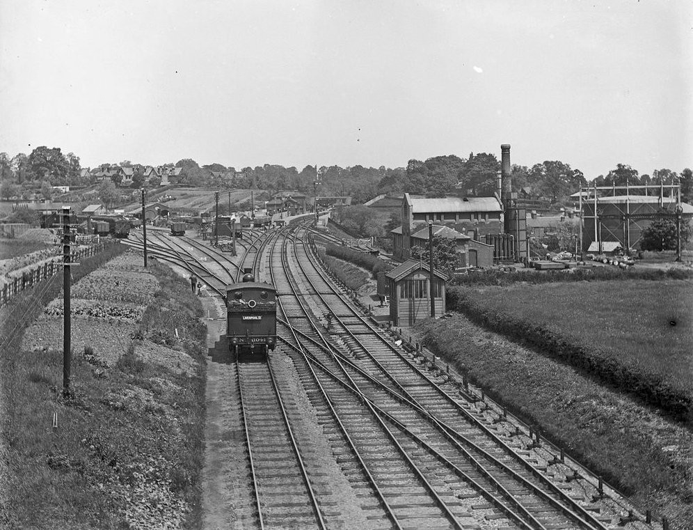
Approaching Epping Station (1903) The photo includes an image of Epping gas works.
Licence:


  Contact us · Copyright policy · Privacy policy