Colombo Street, SE1

Road in/near Southwark, existing between the 1790s and now.

 HOME  ·  ARTICLE  ·  MAPS  ·  STREETS  ·  BLOG  ·  CONTACT US 
(51.50586 -0.10522, 51.505 -0.105) 
MAP YEAR:175018001810182018301860190019502024Show map without markers
TIP: To create your own sharable map, right click on the map
 
Road · * · SE1 ·
October
11
2022
Colombo Street was - until 1937 - called Collingwood Street.

Colombo Street, just south of Christ Church in Blackfriars Road, was at first called Green Walk before it became Collingwood Street. Green Walk, led from the Thames, past Christ Church to a ’tenter ground’ - an area used for drying newly manufactured cloth.

Christ Church had been a new parish formed in 1671 from St Saviour’s, Southwark. The area did not develop until after the building of Blackfriars Bridge and its approach roads during the 1790s. The surrounding marshy ground was drained at the same time.

These cottages of Colombo Street/Collingwood Street were shown on the John Roque map of 1745. The cottages were probably built in the late-seventeenth century and would have been occupied by tradesmen and artisans. They were demolished in 1948 after suffering wartime bomb damage.


Main source: Ideal Homes
Further citations and sources


Click here to explore another London street
We now have 666 completed street histories and 46834 partial histories
Find streets or residential blocks within the M25 by clicking STREETS


CONTRIBUTIONS TO THE LOCALITY

Comment
Peter   
Added: 4 Dec 2023 07:05 GMT   

Gambia Street, SE1
Gambia Street was previously known as William Street.

Reply

LATEST LONDON-WIDE CONTRIBUTIONS TO THE PROJECT

Comment
   
Added: 2 May 2024 16:14 GMT   

Farm Place, W8
The previous name of Farm Place was Ernest St (no A)

Reply
Comment
Tony Whipple   
Added: 16 Apr 2024 21:35 GMT   

Frank Whipple Place, E14
Frank was my great-uncle, I’d often be ’babysat’ by Peggy while Nan and Dad went to the pub. Peggy was a marvel, so full of life. My Dad and Frank didn’t agree on most politics but everyone in the family is proud of him. A genuinely nice, knowledgable bloke. One of a kind.

Reply
Comment
Theresa Penney   
Added: 16 Apr 2024 18:08 GMT   

1 Whites Row
My 2 x great grandparents and his family lived here according to the 1841 census. They were Dutch Ashkenazi Jews born in Amsterdam at the beginning of the 19th century but all their children were born in Spitalfields.

Reply
Comment
Wendy    
Added: 22 Mar 2024 15:33 GMT   

Polygon Buildings
Following the demolition of the Polygon, and prior to the construction of Oakshott Court in 1974, 4 tenement type blocks of flats were built on the site at Clarendon Sq/Phoenix Rd called Polygon Buildings. These were primarily for people working for the Midland Railway and subsequently British Rail. My family lived for 5 years in Block C in the 1950s. It seems that very few photos exist of these buildings.

Reply

Steve   
Added: 19 Mar 2024 08:42 GMT   

Road construction and houses completed
New Charleville Circus road layout shown on Stanford’s Library Map Of London And Its Suburbs 1879 with access via West Hill only.

Plans showing street numbering were recorded in 1888 so we can concluded the houses in Charleville Circus were built by this date.

Source: Charleville Circus, Sydenham, London

Reply
Comment
Steve   
Added: 19 Mar 2024 08:04 GMT   

Charleville Circus, Sydenham: One Place Study (OPS)
One Place Study’s (OPS) are a recent innovation to research and record historical facts/events/people focused on a single place �’ building, street, town etc.

I have created an open access OPS of Charleville Circus on WikiTree that has over a million members across the globe working on a single family tree for everyone to enjoy, for free, forever.

Source: Charleville Circus, Sydenham, London

Reply
Comment
Charles   
Added: 8 Mar 2024 20:45 GMT   

My House
I want to know who lived in my house in the 1860’s.

Reply

NH   
Added: 7 Mar 2024 11:41 GMT   

Telephone House
Donald Hunter House, formerly Telephone House, was the BT Offices closed in 2000

Reply


LOCAL PHOTOS
Click here to see map view of nearby Creative Commons images
Click here to see Creative Commons images near to this postcode
Click here to see Creative Commons images tagged with this road (if applicable)
Postal area SE1
TUM image id: 1483541461
Licence: CC BY 2.0
Amen Court, EC4M
TUM image id: 1493474208
Licence: CC BY 2.0
Ayres Street
TUM image id: 1544924072
Licence:
Farringdon Street, EC4M
TUM image id: 1530111130
Licence:
No 37 Cheapside on the corner of Friday Street (c.1880) The ’Society for Photographing Relics of Old London’ was formed when the Oxford Arms - a traditional galleried pub - was about to be pulled down as part of the new Old Bailey development in 1875. The society subsequently campaigned to record disappearing sights, hurriedly commissioning photographs to capture buildings for posterity. Between 1875 and 1886 they produced photographic records of further buildings under threat, which were issued with descriptive text by the painter (and founder of the Society) Alfred Marks. The focus was architectural, not social; the photographs deliberately exclude signs, notices, people and traffic, to concentrate on the appearance of the bricks and mortar. Few of the streets in their images remain. This section of Friday Street was demolished after the Second World War.
Credit: Society for Photographing Relics of Old London
TUM image id: 1636543684
Licence:
Hopton’s Almshouses
TUM image id: 1513445642
Licence: CC BY 2.0

In the neighbourhood...

Click an image below for a better view...
Hopton’s Almshouses, Hopton Street, Bankside (1957)
Licence:


Tate Modern viewed from Thames pleasure boat (2003)
Credit: Christine Matthews
Licence: CC BY 2.0


Middle Temple Lane looking towards Victoria Embankment (2008) The buildings are mainly occupied by barristers’ chambers
Credit: Wiki Commons/J D Mack
Licence: CC BY 2.0


At the southern end of Carmelite Street in the City of London stood the Victorian-era Whitefriars Fire Station.
Credit: Wiki Commons
Licence:


Railway Bridge 27 XTD, Gambia Street, London
Credit: www.waymarking.com
Licence:


Hopton’s Almshouses
Licence: CC BY 2.0


Postcard of the then-new Victoria Embankment (1890s) The Victoria Embankment was primarily designed by Sir Joseph Bazalgette. It incorporates the main low level interceptor sewer and the underground District Line over which a wide road and riverside walkway were built.
Old London postcard
Licence:


"Traffic on Blackfriars Bridge" is an 1896 British short black-and-white silent actuality film, directed by Robert W. Paul, featuring top-hatted pedestrians and horse-drawn carriages passing over Blackfriars Bridge in London. The movie was, according to Michael Brooke of BFI Screenonline, "taken from the southern end looking northwards over the Thames by R.W. Paul in July 1896" and screened as part of his Alhambra Theatre programme shortly afterwards. Movie link: https://youtu.be/zuFQdN393P0 (198)
Credit: Robert W. Paul
Licence:


Zoar Street (2020) Zoar Street - one of the final streets alphabetically in London - was home to the Zoar Chapel, built by the Baptists of Southwark in 1687. It is believed that John Bunyan preached there shortly before his death the following year. Zoar was the Dead Sea city where Lot sheltered when the Cities of the Plain were destroyed, and is used to mean ’refuge’ or ’sanctuary’.
Credit: The Underground Map
Licence:


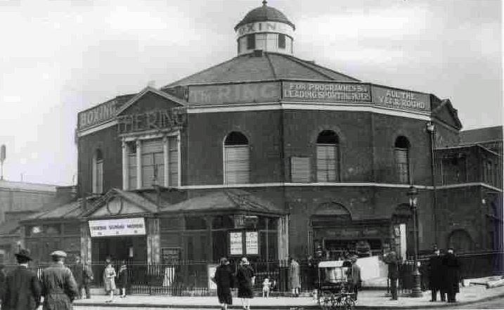
The Ring, Blackfriars Road, SE1 (1925) Although established as a boxing venue in 1910, the building dated from 1783 as the Surrey Congregational Chapel by the Reverend Rowland Hill - who reportedly opted for the unusual, circular design so that there would be no corners in which the devil could hide. The person responsible for overseeing the chapel’s conversion was Dick Burge, a former English middleweight champion from Cheltenham. The former place of worship was then a warehouse. Dick and his wife Bella Burge enlisted the help of local homeless people to clean out the building and transform it into a state fit for presenting boxing to the public. The Ring opened on 14 May 1910, with the Blackfriars arena soon staging events four to five times a week, and the name from the circular shape of the building. The term "boxing ring" is not derived from the name of the building, contrary to local legend, but - still from the capital - instead from the London Prize Ring Rules in 1743, which specified a small circle in the centre of the fight area where the boxers met at the start of each round. The term ’ringside seat’ dates from the 1860s.
Licence:


  Contact us · Copyright policy · Privacy policy